 Filter: Categories of Wisconsin Historical Images
Filter: FULL_DATE of 1900
Filter: County of Brown
Filter: Subject of water
Filter: Categories of Wisconsin Historical Images
Filter: FULL_DATE of 1900
Filter: County of Brown
Filter: Subject of water

| Date: | 1900 |
|---|---|
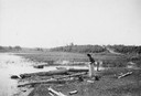
| Description: | Elevated view down hill of the Fox River and the Little Rapids dam. |
| Date: | 1900 |
|---|---|
| Description: | A woman stands in a marsh near the site of Eleazer William's first house. |

| Date: | 1900 |
|---|---|
| Description: | W.W. Cargill Company's grain elevator. |
| Date: | 1900 |
|---|---|
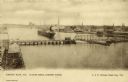
| Description: | Looking North. Harbor with boats, bridge, and buildings. |
| Date: | 1900 |
|---|---|
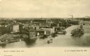
| Description: | Elevated view of east Green Bay harbor with cargo ships, W.W. Cagill Co., and other various industries. |

| Date: | 1900 |
|---|---|
| Description: | View across Fox River towards the St. Norbert's College campus. |

| Date: | 1900 |
|---|---|
| Description: | This map of Green Bay shows plat of the town, lots by number, local streets, the military Fort Howard, part of Fox River and part of Navarino. The map feat... |

| Date: | 1900 |
|---|---|
| Description: | This map of West Navarino shows plat of the town, lots by number, local streets, public square, The Fox River, and Fort Howard. The bottom of the map reads... |
| Date: | 1900 |
|---|---|
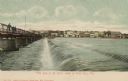
| Description: | Hand-colored postcard view of Fox River dam at De Pere. Men are walking along the bridge on the left. Caption reads: "'The Dam at De Pere,' South of Green ... |
| Date: | 1900 |
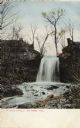
|---|---|
| Description: | View looking up to the falls. Caption reads: "Kittell's Falls, De Pere, Wis." |

| Date: | 1900 |
|---|---|
| Description: | This photostat map was probably originally created in 1835 and shows in addition to private claims, mills, roads, and trails. Green Bay and the Fox River a... |

| Date: | 1900 |
|---|---|
| Description: | This photocopied map shows private claim owners, buildings, and land use in 1818. Insets show Fort Howard and the caption reads: "A view of the Fox River ... |

| Date: | 1900 |
|---|---|
| Description: | This map shows land owners, railroads, and rivers. |

| Date: | 1900 |
|---|---|
| Description: | This photocopy map shows lot and block numbers, some land ownership, street names, and the Fox River. Caption reads, "Mr. P.S. Levy says this map was drawn... |

| Date: | 1900 |
|---|---|
| Description: | This set of maps contains four sheets: "Landownership in the Vicinity of Military Reserve and Fort Howard," "Houses Along the River Road to Green Bay," "Ow... |
If you didn't find the material you searched for, our Library Reference Staff can help.
Call our reference desk at 608-264-6535 or email us at: