Filter: Categories of Wisconsin Historical Images
Filter: FULL_DATE of 1900
Filter: County of Columbia
Filter: Subject of human settlements
Filter: Categories of Wisconsin Historical Images
Filter: FULL_DATE of 1900
Filter: County of Columbia
Filter: Subject of human settlements
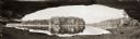
| Date: | 1900 |
|---|---|
| Description: | Panoramic view of the Wisconsin River in the Wisconsin Dells from underneath an overhanging rocky outcropping. A canoe is beached on the far left. The word... |
| Date: | 1900 |
|---|---|
| Description: | Sheriff John MacKenzie poses in front of the Portage jail with his staff. |
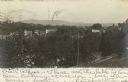
| Date: | 1900 |
|---|---|
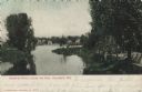
| Description: | Elevated view from hill looking over a river towards Lodi, Wisconsin. Hills are in the distance. |
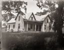
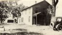
| Date: | 1900 |
|---|---|
| Description: | The home of the Burlingames, possibly belonging either to the parents of Ada Bass or her brother Everett. There is someone outside near the side door. |
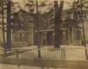
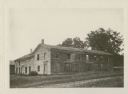
| Date: | 1900 |
|---|---|
| Description: | Elijah Hinkson residence, with a fence in the foreground. Snow is on the ground. |
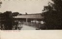
| Date: | 1900 |
|---|---|
| Description: | Covered bridge over river. Caption reads: "The Old Bridge, Portage, Wis." |
| Date: | 1900 |
|---|---|
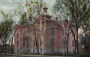
| Description: | View across street towards the Columbia County Court House. Caption reads: Court House, Portage, Wisc." |
| Date: | 1900 |
|---|---|
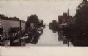
| Description: | Elevated view of the Portage Canal and the canal docks. Caption reads: "The Canal Docks, Portage, Wis." |
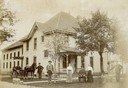
| Date: | 1900 |
|---|---|
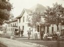
| Description: | Group posing on lawn outside of the large brick building with a steep hip roof. Four men are identified (from left to right) as the turnkey, William MacKen... |

| Date: | 1900 |
|---|---|
| Description: | View down center of street looking west along James Street. There are pedestrians and two horse-drawn carriages on the street. Caption reads: "James St., L... |
| Date: | 1900 |
|---|---|
| Description: | Color-enhanced black and white postcard looking at the dam on the Crawfish River from downstream. Caption reads: "Crawfish River, below the Dam, Columbus, ... |

| Date: | 1900 |
|---|---|
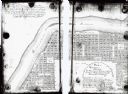
| Description: | This map shows landownership, churches, schools, farm houses, wagon roads, railroads, and townships and includes businesses advertisements, tables of stati... |
| Date: | 1900 |
|---|---|
| Description: | This map shows lots, public squares, landing, streets, and promenade of a paper city on a site now in the Town of West Point, Columbia County. The Wisconsi... |

| Date: | 1900 |
|---|---|
| Description: | This manuscript map shows outline of Fort Winnebago reserve land, Fort Winnebago, claim of A. Grignon, and Indian boundaries. The Fox River and Swan Lake a... |

| Date: | 1900 |
|---|---|
| Description: | This photocopy plat map of Pauquette, now Poynette, shows streets and lot numbers. |
If you didn't find the material you searched for, our Library Reference Staff can help.
Call our reference desk at 608-264-6535 or email us at: