 Filter: Categories of Wisconsin Historical Images
Filter: FULL_DATE of 1900
Filter: County of Crawford
Filter: Subject of water
Filter: Categories of Wisconsin Historical Images
Filter: FULL_DATE of 1900
Filter: County of Crawford
Filter: Subject of water
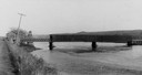
| Date: | 1900 |
|---|---|
| Description: | View from road of a partially covered bridge. Industrial buildings are near the entrance to the bridge on the left. |
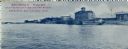
| Date: | 1900 |
|---|---|
| Description: | The Dousman House as seen from the Mississippi River. Caption reads: "Dousman House, East Bank of Mississippi River, Prairie Du Chien, Wis." |
| Date: | 1900 |
|---|---|
| Description: | The Dousman Hotel seen from an elevated view of the Mississippi River. |

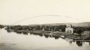
| Date: | 1900 |
|---|---|
| Description: | Chicago, Milwaukee, and St. Paul Railroad pontoon bridge between Marquette, Iowa, and Prairie du Chien. |
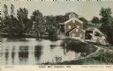
| Date: | 1900 |
|---|---|
| Description: | View of the Lower Mill. Caption reads: "Lower Mill, Poynette, Wis." |

| Date: | 1900 |
|---|---|
| Description: | This map shows a line, marked with latitude and longitude coordinates that runs through Prairie du Chien. Only a few features beyond this line are displaye... |

| Date: | 1900 |
|---|---|
| Description: | This photocopy map shows marshes, woods, buildings, and selected features including islands, mounds, old Fort Crawford, and "new site for a fort in questio... |

| Date: | 1900 |
|---|---|
| Description: | This photocopy map shows blocks, lots, subdivisions, city wards, buildings, some landownership, and the Mississippi River. The map margins include business... |
If you didn't find the material you searched for, our Library Reference Staff can help.
Call our reference desk at 608-264-6535 or email us at: