 Filter: Categories of Wisconsin Historical Images
Filter: FULL_DATE of 1900
Filter: Subject of lumber trade
Filter: Categories of Wisconsin Historical Images
Filter: FULL_DATE of 1900
Filter: Subject of lumber trade
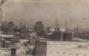
| Date: | 1900 |
|---|---|
| Description: | Elevated view of men, women, and a child posing on boards at a lumbering and sawmill operation. The camp was operated by Edward Hahn, who named the communi... |

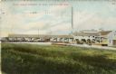
| Date: | 1900 |
|---|---|
| Description: | F.G. and C.A. Stanley Manufacturing Plant. There is a plank sidewalk in the foreground. |
| Date: | 1900 |
|---|---|
| Description: | View up the Eau Claire River from the Dewey Street Bridge. The view shows the dam and linen mill and the site of the lower sawmill (called the "steam mill"... |
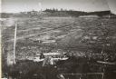
| Date: | 1900 |
|---|---|
| Description: | Lake Shore Lumber Company of Oshkosh's mill waste lumber slab dump. Leander Choate, owner of mill, used this marsh for his waste lumber which was piled at ... |
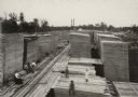
| Date: | 1900 |
|---|---|
| Description: | Two ships at the end of the canal, several buildings, a small lumberyard, and snow. Three other ships are visible down the canal. |

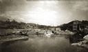
| Date: | 1900 |
|---|---|
| Description: | View across Chippewa River of the Big Lumber Mill on the opposite bank. |
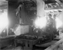
| Date: | 1900 |
|---|---|
| Description: | Two men using sawing machinery to make boards inside "Big Mill." |

| Date: | 1900 |
|---|---|
| Description: | Shows limits of drainage basin, dams, rapids, roads, and railroads in parts of Iron and Vilas Counties, Wisconsin. From the E.P. Sherry papers relating to ... |
| Date: | 1900 |
|---|---|
| Description: | Colorized postcard view across field toward the lumber mill. Caption reads: "Dan'l Shaw Lumber Company Mill, Eau Claire, Wis." |
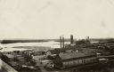
| Date: | 1900 |
|---|---|
| Description: | Elevated view of a lumber plant, with large stacks of lumber stacked around it. A lake is behind the plant. |

| Date: | 1900 |
|---|---|
| Description: | A Sanborn fire insurance map of Sauk City created in 1900. |

| Date: | 1900 |
|---|---|
| Description: | A Sanborn fire insurance map of Sauk City created in 1900. |
If you didn't find the material you searched for, our Library Reference Staff can help.
Call our reference desk at 608-264-6535 or email us at:

