Filter: Categories of Wisconsin Historical Images
Filter: FULL_DATE of 1900
Filter: Subject of sawmills
Filter: Categories of Wisconsin Historical Images
Filter: FULL_DATE of 1900
Filter: Subject of sawmills
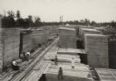
| Date: | 1900 |
|---|---|
| Description: | Elevated view of men, women, and a child posing on boards at a lumbering and sawmill operation. The camp was operated by Edward Hahn, who named the communi... |
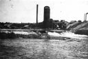
| Date: | 1900 |
|---|---|
| Description: | View up the Eau Claire River from the Dewey Street Bridge. The view shows the dam and linen mill and the site of the lower sawmill (called the "steam mill"... |
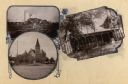
| Date: | 1900 |
|---|---|
| Description: | Composite of views of Oakwood Beach Lodge, Pioneer Presbyterian Church and a sawmill. |
| Date: | 1900 |
|---|---|
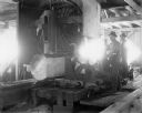
| Description: | Two men using sawing machinery to make boards inside "Big Mill." |
| Date: | 1900 |
|---|---|
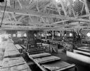
| Description: | Interior view of large room filled with machinery inside a lumber mill. |

| Date: | 1900 |
|---|---|
| Description: | This 1900 map shows the township and range system, sections, cities and villages, railroads, roads, vacant land and land sold by the Wisconsin Central Rail... |

| Date: | 1900 |
|---|---|
| Description: | Shows lands belonging to Wisconsin Timber and Land Co., towns, post offices, saw mills, creameries, camps, churches, schools, farm houses, town halls, rail... |

| Date: | 1900 |
|---|---|
| Description: | Man standing in front of a sawmill waterway. In the background on the opposite shoreline are the sawmill buildings. |
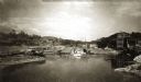
| Date: | 1900 |
|---|---|
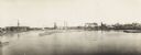
| Description: | Semi-panoramic view of a river town showing extensive sawmill operations. |

| Date: | 1900 |
|---|---|
| Description: | This photostat of a manuscript map originally drawn in 1829 shows landownership, buildings, including Fort Howard and U.S. sawmill, swamps, public barns an... |

| Date: | 1900 |
|---|---|
| Description: | This photostat map shows private claim owners, natural meadows, roads, saw and grist mills, and Fort Howard. The upper right corner includes annotations an... |

| Date: | 1900 |
|---|---|
| Description: | This photostat map was probably originally created in 1835 and shows in addition to private claims, mills, roads, and trails. Green Bay and the Fox River a... |
If you didn't find the material you searched for, our Library Reference Staff can help.
Call our reference desk at 608-264-6535 or email us at: