Filter: Categories of Wisconsin Historical Images
Filter: FULL_DATE of 1900
Filter: Subject of schools
Filter: Categories of Wisconsin Historical Images
Filter: FULL_DATE of 1900
Filter: Subject of schools
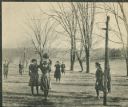
| Date: | 1900 |
|---|---|
| Description: | Girls playing basketball outdoors at Hillside Home School, an early progressive school operated by Ellen and Jane Lloyd Jones, aunts of Frank Lloyd Wright. |
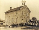
| Date: | 1900 |
|---|---|
| Description: | The "Rock School" building, with children and teachers posed outside. |

| Date: | 1900 |
|---|---|
| Description: | View down hill of Machine Shop, Electrical Laboratory and Industrial Arts Laboratory, on the University of Wisconsin-Madison campus. |

| Date: | 1900 |
|---|---|
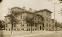
| Description: | Exterior view across path toward a school house. On the left are stairs and a handrail leading to the basement area. |

| Date: | 1900 |
|---|---|
| Description: | Perspective drawing of the buildings at the Hayward Indian School. There is a man in a boat in the right foreground and an empty boat in the left foregroun... |

| Date: | 1900 |
|---|---|
| Description: | Parocial [sic] School. View from front of the two-story brick school building with a steep, snow-covered hill behind it. The negative is marked 'Souvenir'. |

| Date: | 1900 |
|---|---|
| Description: | A map of Jefferson County, Wisconsin, that identifies named hills, other points of interest, and the Lake Mills moraine system in the county and identifies... |

| Date: | 1900 |
|---|---|
| Description: | A map of Marinette County, Wisconsin shows the township and range system, sections, towns, cities and villages, streams and lakes, railroads, roads, school... |

| Date: | 1900 |
|---|---|
| Description: | Outdoor portrait of the entire student body posing on the porches and balconies, and on the grounds of the school. A few people are also posing in some of ... |

| Date: | 1900 |
|---|---|
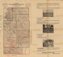
| Description: | This map of Sawyer County, Wisconsin, shows the numbered "sub-school-districts of the town of Hayward" school houses, and the Indian reservation. The towns... |

| Date: | 1900 |
|---|---|
| Description: | This 1900 map shows the township and range system, sections, cities and villages, railroads, roads, vacant land and land sold by the Wisconsin Central Rail... |
| Date: | 1900 |
|---|---|
| Description: | This map of Taylor County, Wisconsin, shows landownership, the township and range grid, towns, sections, cities and villages, railroads, tanneries, cemeter... |
| Date: | 1900 |
|---|---|
| Description: | This map from the turn of the 20th century shows the township and range grid, sections, towns, land owned by the Starks Levis Land Company of Madison, scho... |

| Date: | 1900 |
|---|---|
| Description: | This early 20th century map of Chippewa County, Wisconsin, shows the township and range grid, towns, sections, cities and villages, roads, railroads, schoo... |

| Date: | 1900 |
|---|---|
| Description: | This map includes an index of streets and schools, and shows parks and public lands, as well as industrial sites. |

| Date: | 1900 |
|---|---|
| Description: | This map is shows land in white and water in blue and is indexed for parks, points of interest, schools, churches, and recreational areas. The map shows lo... |

| Date: | 1900 |
|---|---|
| Description: | This map shows landownership, churches, schools, farm houses, wagon roads, railroads, and townships and includes businesses advertisements, tables of stati... |

| Date: | 1900 |
|---|---|
| Description: | This map shows landownership, railroads, roads, churches, schools, cemeteries, post offices, townships, city wards, Lake Michigan, and rivers. The map incl... |
If you didn't find the material you searched for, our Library Reference Staff can help.
Call our reference desk at 608-264-6535 or email us at: