 Filter: Categories of Wisconsin Historical Images
Filter: FULL_DATE of 1900
Filter: Subject of streams
Filter: Categories of Wisconsin Historical Images
Filter: FULL_DATE of 1900
Filter: Subject of streams
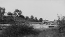
| Date: | 1900 |
|---|---|
| Description: | View from shoreline of Duncan Creek, a dam, and a flour mill. |
| Date: | 1900 |
|---|---|
| Description: | Group of three women, including Ada Bass, at the base of Minnehaha Falls. Minnehaha Creek in foreground. |
| Date: | 1900 |
|---|---|
| Description: | Unidentified woman standing on the footbridge at the base of Minnehaha Falls. Minnehaha Creek in foreground. |
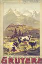
| Date: | 1900 |
|---|---|
| Description: | An original colored lithograph advertising the Chemins de fer électriques de la Gruyèr railway in Switzerland. The poster features the artist Anton Reckzi... |

| Date: | 1900 |
|---|---|
| Description: | A map of Jefferson County, Wisconsin, that identifies named hills, other points of interest, and the Lake Mills moraine system in the county and identifies... |

| Date: | 1900 |
|---|---|
| Description: | A map of Marinette County, Wisconsin shows the township and range system, sections, towns, cities and villages, streams and lakes, railroads, roads, school... |
| Date: | 1900 |
|---|---|
| Description: | This map of Polk County, Wisconsin, from the early 20th century shows the land for sale by the Cushing Land Agency of Saint Croix Falls. The township and r... |

| Date: | 1900 |
|---|---|
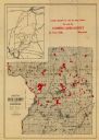
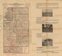
| Description: | This 1900 map shows the township and range system, sections, cities and villages, railroads, roads, vacant land and land sold by the Wisconsin Central Rail... |
| Date: | 1900 |
|---|---|
| Description: | This map of Taylor County, Wisconsin, shows landownership, the township and range grid, towns, sections, cities and villages, railroads, tanneries, cemeter... |

| Date: | 1900 |
|---|---|
| Description: | This 1900 map of Walworth County, Wisconsin, shows the township and range grid, towns, sections, landownership and acreages, rural residences, cities and v... |
| Date: | 1900 |
|---|---|
| Description: | This map from the turn of the 20th century shows the township and range grid, sections, towns, land owned by the Starks Levis Land Company of Madison, scho... |

| Date: | 1900 |
|---|---|
| Description: | This early 20th century map of Chippewa County, Wisconsin, shows the township and range grid, towns, sections, cities and villages, roads, railroads, schoo... |

| Date: | 1900 |
|---|---|
| Description: | This 1900 map of Waukesha County, Wisconsin, shows the township and range grid, towns, sections, cities and villages, rural landowners and acreages, railro... |

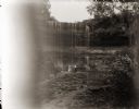
| Date: | 1900 |
|---|---|
| Description: | Country road crossing ford of a small stream. A rail fence runs along the left side of the road. |
| Date: | 1900 |
|---|---|
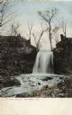
| Description: | View looking up to the falls. Caption reads: "Kittell's Falls, De Pere, Wis." |

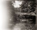
| Date: | 1900 |
|---|---|
| Description: | View across field. Along the right is a creek. |
| Date: | 1900 |
|---|---|
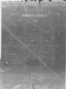
| Description: | This map shows the blocks and streets that make up the village, and includes the Baraboo Air Line Railroad which cuts through the village at a diagonal fro... |
If you didn't find the material you searched for, our Library Reference Staff can help.
Call our reference desk at 608-264-6535 or email us at: