 Filter: Categories of Wisconsin Historical Images
Filter: FULL_DATE of 1900
Filter: Subject of superior, lake
Filter: Categories of Wisconsin Historical Images
Filter: FULL_DATE of 1900
Filter: Subject of superior, lake

| Date: | 1900 |
|---|---|
| Description: | View of La Pointe, Madeline Island, taken from the Mission Inn. |

| Date: | 1900 |
|---|---|
| Description: | The house of Captain Angus on the shore of Lake Superior in La Pointe on Madeline Island sometime around 1900. The Angus family came to Madeline Island in ... |
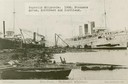
| Date: | 1900 |
|---|---|
| Description: | The Superior Shipyards showing steamers "Moran", "Northwest" and "Northland. Caption reads: "Ship Yards — McDougall Whaleback. West Superior, Wis." |

| Date: | 1900 |
|---|---|
| Description: | Elevated view of Tower Avenue. Caption reads: "Tower Avenue, Superior, Wis." |
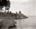
| Date: | 1900 |
|---|---|
| Description: | View of Hougton Point and Bayfield from Madeline Island. |

| Date: | 1900 |
|---|---|
| Description: | A map of Wisconsin, eastern Minnesota and Iowa, northern Iowa, and Michigan’s Upper Peninsula, showing railway lines, with those marked with heavy red line... |

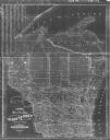
| Date: | 1900 |
|---|---|
| Description: | This map, which shows the state of Wisconsin in 1895, was published as Rand, McNally & Co.'s New business atlas map of Wisconsin. Railroads, counties, citi... |

| Date: | 1900 |
|---|---|
| Description: | A map of Wisconsin, eastern Minnesota and Iowa, and Michigan’s Upper Peninsula, showing the rail lines of the Wisconsin Central Railroad are shown in red, ... |

| Date: | 1900 |
|---|---|
| Description: | This chart of the northern Apostle Islands and Lake Superior shoreline shows relief by contours and spot heights and depths by contours, gradient tints and... |

| Date: | 1900 |
|---|---|
| Description: | This map shows streets, railroads, dock and harbor lines, and parks. The map includes population tables for 1880, 1890, 1900. |

| Date: | 1900 |
|---|---|
| Description: | This map shows railroad routes in red, blue, orange, brown, pink, green, and dotted, as well as lakes, rivers, and communities. The map includes a legend i... |

| Date: | 1900 |
|---|---|
| Description: | This map shows AS&IR Railroad between Siskiwit and Nash (with dock), a proposed extension of AS&IR Railroad "now under construction" between Superior and N... |
| Date: | 1900 |
|---|---|
| Description: | This map shows county boundaries, towns, waterways,towns, railroads and proposed railroads, Lake Michigan and Superior. A Portion of Michigan is visible. O... |
If you didn't find the material you searched for, our Library Reference Staff can help.
Call our reference desk at 608-264-6535 or email us at: