 Filter: Categories of Wisconsin Historical Images
Filter: FULL_DATE of 1901
Filter: Subject of lakes
Filter: Categories of Wisconsin Historical Images
Filter: FULL_DATE of 1901
Filter: Subject of lakes

| Date: | 1901 |
|---|---|
| Description: | This 1901 map of Barron County, Wisconsin, shows the township and range grid, towns, cities and villages, roads, railroads, and lakes and streams. |

| Date: | 1901 |
|---|---|
| Description: | Map shows townships, schools, creameries, post offices, and roads. The left side of the map features a legend with symbols for points of interest. |

| Date: | 1901 |
|---|---|
| Description: | This map shows streets, industrial buildings, a portion of Lake Superior and other lakes, bays, and rivers in portions of Duluth and Superior. Relief is sh... |

| Date: | 1901 |
|---|---|
| Description: | This map shows landownership and acreages, townships and sections, and selected buildings. |
| Date: | 1901 |
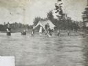
|---|---|
| Description: | A group of children, supervised by adults, is playing at the bathing beach on Archibald Lake. On the shore is a tent with a woman sitting inside. Caption r... |

| Date: | 1901 |
|---|---|
| Description: | George Brumder, Milwaukee publisher and businessman, standing on his pier at Pine Lake. He is wearing a suit and hat. There is a low wall on the right, whi... |
If you didn't find the material you searched for, our Library Reference Staff can help.
Call our reference desk at 608-264-6535 or email us at: