 Filter: Categories of Wisconsin Historical Images
Filter: FULL_DATE of 1901
Filter: Subject of land
Filter: Categories of Wisconsin Historical Images
Filter: FULL_DATE of 1901
Filter: Subject of land
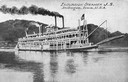
| Date: | 1901 |
|---|---|
| Description: | The sternwheel excursion, J.S. in the middle of the Mississippi River. The opposite shoreline is in the background. |
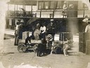
| Date: | 1901 |
|---|---|
| Description: | Colonel and Mrs. Woods (right center) arriving on Madeline Island dock for summer visit. Thomas Stahl and his dog team (at left), loading luggage into dog ... |
| Date: | 1901 |
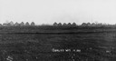
|---|---|
| Description: | Thirteen unfinished houses in a row, on the horizon of a field. Captin reads: "Corliss Wis In 1901". |
| Date: | 1901 |
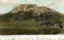
|---|---|
| Description: | Grand Dad Bluff in La Crosse with the Crusher building which was built in 1901 and burned in 1902. Caption reads: "Grand Dad Bluff, La Crosse, Wis." |

| Date: | 1901 |
|---|---|
| Description: | A man is standing on the deck of a large ship as it travels the Hudson River. Other passengers are sitting on benches in the background. |

| Date: | 1901 |
|---|---|
| Description: | Syl and aunt Helen holding walking sticks at the edge of a steep cliff. Behind them far below is a lake or a river and far shoreline. |
| Date: | 1901 |
|---|---|
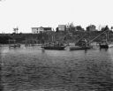
| Description: | Boys are standing on boats, catching red horse fish using dip nets in the Crawfish River. The dip nets are set up on scaffolds in the river. In the backgro... |
| Date: | 1901 |
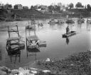
|---|---|
| Description: | View from shoreline of a man standing in a boat, dipping for carp on the Crawfish River. Behind him dip nets are set up on scaffolds in the river. There ar... |

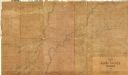
| Date: | 1901 |
|---|---|
| Description: | A hand-colored map of Iowa County, Wisconsin, shows townships and sections, towns, cities and villages, streams, landownership, roads, railroads and rural ... |

| Date: | 1901 |
|---|---|
| Description: | This 1901 map of Barron County, Wisconsin, shows the township and range grid, towns, cities and villages, roads, railroads, and lakes and streams. |
| Date: | 1901 |
|---|---|
| Description: | Shows townships and sections, landownership and acreages, and rural buildings in what is now known as Rusk County. |

| Date: | 1901 |
|---|---|
| Description: | Map shows townships, schools, creameries, post offices, and roads. The left side of the map features a legend with symbols for points of interest. |
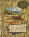
| Date: | 1901 |
|---|---|
| Description: | Front cover featuring a color illustration of wheat, clover flowers, and a calendar for 1901, around an inset illustration of a farmer working in a field w... |

| Date: | 1901 |
|---|---|
| Description: | This map shows landownership and acreages, townships and sections, and selected buildings. |

| Date: | 1901 |
|---|---|
| Description: | A Sanborn map of Tomahawk featuring the Bay Mill Company's lumber yard. |
| Date: | 1901 |
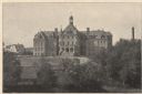
|---|---|
| Description: | View of the east facade of the three-story brick hospital with its Richardsonian Romanesque arched stone entrance and Roman Catholic cross-topped turrets. ... |

| Date: | 1901 |
|---|---|
| Description: | Stereograph of a formation on the Wisconsin River called "The Ink Stand." On the shore a woman is sitting on a wooden bench, and behind her is a picnic bas... |
| Date: | 1901 |
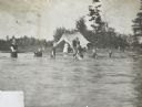
|---|---|
| Description: | A group of children, supervised by adults, is playing at the bathing beach on Archibald Lake. On the shore is a tent with a woman sitting inside. Caption r... |

| Date: | 1901 |
|---|---|
| Description: | A woman wearing a long skirt and blouse is standing and holding baby Eleanor Holt in her arms while standing on the front porch of Island Lodge on Archibal... |

| Date: | 1901 |
|---|---|
| Description: | A plat map of Marathon county, 28 township, north range, 7 east. |
If you didn't find the material you searched for, our Library Reference Staff can help.
Call our reference desk at 608-264-6535 or email us at: