Filter: Categories of Wisconsin Historical Images
Filter: FULL_DATE of 1901
Filter: Subject of roads
Filter: Categories of Wisconsin Historical Images
Filter: FULL_DATE of 1901
Filter: Subject of roads
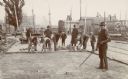
| Date: | 1901 |
|---|---|
| Description: | A crew of construction workers paving North Main Street with brick. |
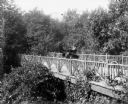
| Date: | 1901 |
|---|---|
| Description: | A.G. Zimmerman parked on an artfully rustic, wooden bridge in his automobile, a "locomobile steamer," on Mendota Drive. |
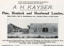
| Date: | 1901 |
|---|---|
| Description: | An advertisement for the A.H. Kayser lumberyard at 204 East Washington Avenue. |
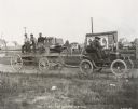
| Date: | 1901 |
|---|---|
| Description: | Thomas B. Jeffery's first Rambler automobile during a test for strength in Kenosha, Wisconsin. |
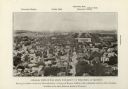
| Date: | 1901 |
|---|---|
| Description: | Elevated view looking west down State Street towards the University of Wisconsin. Caption reads: "General View of the State University of Wisconsin, at Mad... |

| Date: | 1901 |
|---|---|
| Description: | Elevated view looking Northeast from dome of the Milwaukee County Court House. Several churches are visible among the dwellings. |

| Date: | 1901 |
|---|---|
| Description: | A hand-colored map of Iowa County, Wisconsin, shows townships and sections, towns, cities and villages, streams, landownership, roads, railroads and rural ... |

| Date: | 1901 |
|---|---|
| Description: | This 1901 map of Barron County, Wisconsin, shows the township and range grid, towns, cities and villages, roads, railroads, and lakes and streams. |

| Date: | 1901 |
|---|---|
| Description: | Map shows townships, schools, creameries, post offices, and roads. The left side of the map features a legend with symbols for points of interest. |
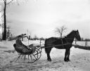
| Date: | 1901 |
|---|---|
| Description: | Winter scene with Joseph Langenbach sitting in a horse-drawn cutter (sleigh) at the end of the snowy driveway. In the background is a fence and a U.S. Mail... |

| Date: | 1901 |
|---|---|
| Description: | This map shows public schools, engine houses, railroads, street railways, city wards, parks, block numbers, and Lake Michigan. Also included are indexes, t... |

| Date: | 1901 |
|---|---|
| Description: | This map shows city wards, block numbers, parks, cemeteries, roads, railroads, Lake Michigan, and selected buildings. Also included are indexes "Milwaukee ... |

| Date: | 1901 |
|---|---|
| Description: | A Sanborn map of Tomahawk featuring the Bay Mill Company's lumber yard. |
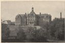
| Date: | 1901 |
|---|---|
| Description: | View of the east facade of the three-story brick hospital with its Richardsonian Romanesque arched stone entrance and Roman Catholic cross-topped turrets. ... |

| Date: | 1901 |
|---|---|
| Description: | A plat map of Marathon county, 28 township, north range, 7 east. |

| Date: | 1901 |
|---|---|
| Description: | A plat map of Marathon county, township 28, north range, 8 east. |

| Date: | 1901 |
|---|---|
| Description: | A plat map of Marathon county, township 29, north range, 7 east. |

| Date: | 1901 |
|---|---|
| Description: | Plat map showing land ownership of Township 21N Range 3W in Jackson County for 1901. Scale is 2 inches to 1 mile. |
If you didn't find the material you searched for, our Library Reference Staff can help.
Call our reference desk at 608-264-6535 or email us at: