 Filter: Categories of Wisconsin Historical Images
Filter: FULL_DATE of 1903
Filter: Subject of railroads
Filter: Categories of Wisconsin Historical Images
Filter: FULL_DATE of 1903
Filter: Subject of railroads
| Date: | 1903 |
|---|---|
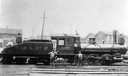
| Description: | Chicago, Milwaukee and St. Paul railroad locomotive #1100, a class I engine, built by the Baldwin Locomotive Works in 1873 and originally numbered #199. Th... |
| Date: | 1903 |
|---|---|
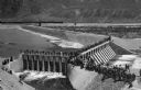
| Description: | Elevated view of Derby Diversion Dam with a crowd gathered on the rim of the dam and individuals standing along its top. A train cuts across the horizon in... |
| Date: | 1903 |
|---|---|
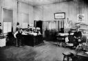
| Description: | Superintendent J.N. Harrison and dispatcher W.H. Wright are seated at desks in the Wisconsin & Michigan Railroad office. |

| Date: | 1903 |
|---|---|
| Description: | A map of northern Wisconsin and Michigan showing the names and locations hunting and fishing resorts in the area, as well as location of Chicago and North ... |

| Date: | 1903 |
|---|---|
| Description: | A map that shows the location of each county, city and village in Wisconsin; in addition that maps also identifies railroads their distances between cities... |

| Date: | 1903 |
|---|---|
| Description: | This 1903 map of Outagamie County, Wisconsin, shows the township and range grid, towns, sections, cities and villages, landownership and acreages, rural ma... |

| Date: | 1903 |
|---|---|
| Description: | This map of Richland County, Wisconsin, shows land ownership and acreages, the township and range grid, sections, cities, towns and post offices, roads, ra... |

| Date: | 1903 |
|---|---|
| Description: | Map of Brown County, Wisconsin, shows the township and range grid, towns, sections, cities, villages and post offices, land owners and acreages, railroads,... |

| Date: | 1903 |
|---|---|
| Description: | Map shows railroads, roads, street car lines, schools, churches, cemeteries, town halls, and railroad stations. Includes inset lists of: Population of Milw... |

| Date: | 1903 |
|---|---|
| Description: | Railroad pass for the Hillsboro and North Eastern Railroad. A short track spanning from Hillsboro to Union Center, the Railroad was in operation from 1903 ... |

| Date: | 1903 |
|---|---|
| Description: | This map shows lakes, rivers, railroads, and the soil types of towns and counties. A legend of soil types and conventional signs is included. Relief is sho... |

| Date: | 1903 |
|---|---|
| Description: | This map shows lakes, roads, railroads, townships, and land ownership by name. Counties are colored red, blue, or yellow. Lake Michigan is labeled. Also in... |

| Date: | 1903 |
|---|---|
| Description: | This map shows townships and sections, landownership and acreages, roads, railroads, and selected rural buildings. Townships and sections appear in yellow,... |

| Date: | 1903 |
|---|---|
| Description: | This map shows landownership, buildings, roads, railroads, townships, cemeteries, and schools. The map also includes population tables, created from the 19... |

| Date: | 1903 |
|---|---|
| Description: | This blue line print shows quartzite areas, mines, railroads, and roads. The map covers townships 11-13 north, ranges 4-8 east, in parts of Sauk and Columb... |

| Date: | 1903 |
|---|---|
| Description: | Switchman standing at the switch next to railroad tracks cut through a rock formation. Another man is standing on top of the rock formation on the left. In... |
If you didn't find the material you searched for, our Library Reference Staff can help.
Call our reference desk at 608-264-6535 or email us at: