 Filter: Categories of Wisconsin Historical Images
Filter: FULL_DATE of 1906
Filter: Community of Madison
Filter: Subject of water
Filter: Categories of Wisconsin Historical Images
Filter: FULL_DATE of 1906
Filter: Community of Madison
Filter: Subject of water
| Date: | 1906 |
|---|---|
| Description: | View of Madison from Lake Monona with the Wisconsin State Capitol building in the background. This view of Brittingham Park shows a part of the park shortl... |
| Date: | 1906 |
|---|---|
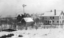
| Description: | View of University Heights, showing a number of university buildings on the agricultural campus, including a windmill. Lake Mendota is in the far backgroun... |

| Date: | 1906 |
|---|---|
| Description: | View from shoreline looking over a pathway towards the Steensland Bridge and Yahara River Parkway at East Washington Avenue. |

| Date: | 1906 |
|---|---|
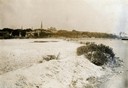
| Description: | Shacks at the foot of North Main Street along Lake Monona near what later became Brittingham Park. |

| Date: | 1906 |
|---|---|
| Description: | Area at the foot of West Main Street, which is now Brittingham Park. Weatherworn buildings are on the right. |

| Date: | 1906 |
|---|---|
| Description: | View of Lake Mendota Drive at the foot of Stevens Hill. |
| Date: | 1906 |
|---|---|
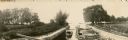
| Description: | A boat full of men and women is entering the lock on the Yahara River at Tenney Park. |
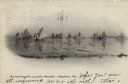
| Date: | 1906 |
|---|---|
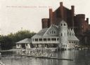
| Description: | View towards shoreline from Lake Mendota of University of Wisconsin-Madison varsity men's rowing crew. People are watching from the boathouse in the backgr... |

| Date: | 1906 |
|---|---|
| Description: | Hand-drawn topographical map of the Turville Estate. |

| Date: | 1906 |
|---|---|
| Description: | Topographical map of Turville Point and lands to the South to Nine Springs Creek. |

| Date: | 1906 |
|---|---|
| Description: | This map is pen-and-ink on paper. The relief is shown by contours and spot heights. "5’ contours." Includes area table. |

| Date: | 1906 |
|---|---|
| Description: | This map shows shows streets, subdivisions, railroads, places of interest including the State Capitol, the University of Wisconsin, Camp Randall, Henry Vil... |
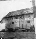
| Date: | 1906 |
|---|---|
| Description: | Angle Worm Station, at the foot of South Carroll Street on Lake Monona. The signs on the building advertise: the "Dane County Fair," "Nichols Sells Souveni... |
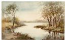
| Date: | 1906 |
|---|---|
| Description: | Watercolor painting of the Yahara River at Lake Monona. |
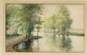
| Date: | 1906 |
|---|---|
| Description: | Watercolor painting of the Yahara River at Lake Monona, with trees in the background and wetlands in the foreground. |
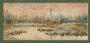
| Date: | 1906 |
|---|---|
| Description: | Watercolor painting of the Yahara River, with large trees on the shoreline. Note: '05 & '06 were the years when Tenney Park and the Yahara River Parkway ... |
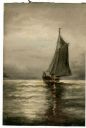
| Date: | 1906 |
|---|---|
| Description: | Watercolor painting of a sailboat on Lake Mendota. |

| Date: | 1906 |
|---|---|
| Description: | View across water towards the Tenney Park bridge. Trees are along the shoreline. Caption reads: "Lagoon, Tenney Park, Madison, Wisconsin." There is a handw... |

| Date: | 1906 |
|---|---|
| Description: | View of the foot bridge crossing the lagoon at Tenney Park. Caption reads: "Lagoon, Tenney Park, Madison, Wisconsin." |
| Date: | 1906 |
|---|---|
| Description: | View of several ice boats on Lake Mendota. Caption reads: "Ice boat regatta on Lake Mendota--Madison, Wis." |
If you didn't find the material you searched for, our Library Reference Staff can help.
Call our reference desk at 608-264-6535 or email us at: