 Filter: Categories of Wisconsin Historical Images
Filter: FULL_DATE of 1906
Filter: County of Milwaukee
Filter: Categories of Wisconsin Historical Images
Filter: FULL_DATE of 1906
Filter: County of Milwaukee

| Date: | 1906 |
|---|---|
| Description: | Bird's-eye map of South Milwaukee. |
| Date: | 1906 |
|---|---|
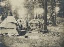
| Description: | The Lac Courte Oreilles village sponsored by the Wisconsin Archaeological Society at the 1906 Wisconsin State Fair. Several members of the society are incl... |
| Date: | 1906 |
|---|---|
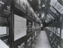
| Description: | 1904 Exhibit of the Maryland Association for the Prevention and Relief of Tuberculosis, in a railway coach. Photograph taken in Milwaukee. |

| Date: | 1906 |
|---|---|
| Description: | Polyconic projection. Map made from surveys without spirit level control. Henry Gannett, Chief Topographer. Topography by Van H. Manning and Nat. Tyler, Jr... |
| Date: | 1906 |
|---|---|
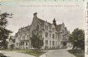
| Description: | Administration building for the school. The building has over three stories, and a covered main entrance. Caption reads: "Administration Building, Industri... |
| Date: | 1906 |
|---|---|
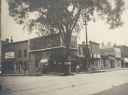
| Description: | A large tree stands in the street at the corner, with signs attached to it. Behind the tree is a cigar store with a large billboard for a furniture store a... |
| Date: | 1906 |
|---|---|
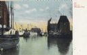
| Description: | Boats on the Milwaukee River. Caption reads: "Boats on Milwaukee River." |
| Date: | 1906 |
|---|---|
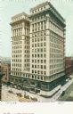
| Description: | Elevated view of the Wells Building. Caption reads: "Wells Building, Milwaukee, Wis." |

| Date: | 1906 |
|---|---|
| Description: | View from street of theatre and main entrance on corner of Wells and Water Streets. To the right is a building with a sign for Quaker Oats. On the left cor... |
| Date: | 1906 |
|---|---|
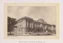
| Description: | Milwaukee Public Library and Museum, designed by Ferry & Clas, architects. |
| Date: | 1906 |
|---|---|
| Description: | A section of the building at the right was erected in 1859; the section at the left is of later construction. The building was torn down in 1911. A car i... |

| Date: | 1906 |
|---|---|
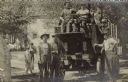
| Description: | Pawling & Harnischfeger 40-ton bridge crane with a 10-ton 2 block type "A" trolley and two hooks. The crane is located at the West Allis Works. The crane i... |
| Date: | 1906 |
|---|---|
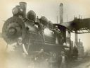
| Description: | Five railroad employees pose on Chicago, Milwaukee & St. Paul Railway engine no. 1223 at the Chestnut Street yard. Left to right are yardman Jack Meyer, ya... |
| Date: | 1906 |
|---|---|
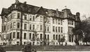
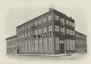
| Description: | An exterior view of the Milwaukee School of Trades. |

| Date: | 1906 |
|---|---|
| Description: | Informal portrait of Katherine Morrissey Dodge Cook seated at a desk in front of a classroom full of students. |
| Date: | 1906 |
|---|---|
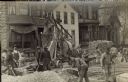
| Description: | Traffic to the J. Ohlenforst Bakery at 529 S. Sixth Street, in the Walker's Point neighborhood, is impeded by street construction. There are piles of grave... |
| Date: | 1906 |
|---|---|
| Description: | John Hahn is leaning on a motorized moving van in the S. Sixth Street neighborhood of Walker's Point. At the steering wheel is a man, with another seated n... |

| Date: | 1906 |
|---|---|
| Description: | This map shows ward boundaries, subdivisions, lot and block numbers and dimensions, house numbers, electric car lines, steam railways, and adjoining plat n... |

| Date: | 1906 |
|---|---|
| Description: | This map shows ward boundaries, lot and block numbers and dimensions, house numbers, electric car lines, steam railways, and adjoining plat numbers in a po... |

| Date: | 1906 |
|---|---|
| Description: | This map shows wards, schools, engine houses, railroads, street railways, block numbers, parks, roads, and Lake Michigan. Also included are indexes: Table ... |
If you didn't find the material you searched for, our Library Reference Staff can help.
Call our reference desk at 608-264-6535 or email us at: