 Filter: Categories of Wisconsin Historical Images
Filter: FULL_DATE of 1907
Filter: Subject of transportation
Filter: Categories of Wisconsin Historical Images
Filter: FULL_DATE of 1907
Filter: Subject of transportation
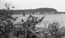
| Date: | 1907 |
|---|---|
| Description: | View across Fish Creek Harbor to the village of Fish Creek and its pier, with warehouse. On the right is Dr. Weckler's Resort, a large wooden building with... |
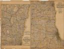
| Date: | 1907 |
|---|---|
| Description: | The first map shows the area from Milwaukee north to Green Bay and west to Columbus; the second map displays the area between Chicago and Milwaukee and wes... |

| Date: | 1907 |
|---|---|
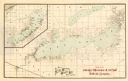
| Description: | A map of the eastern portion of the Apostle Islands group, and a detailed map of Gull Island showing the relief on the island, are included here, along wit... |

| Date: | 1907 |
|---|---|
| Description: | Four men are transporting a cart of goods from a railroad car to a loading dock. The men are most likely employees of the International Harvester Osbourne ... |

| Date: | 1907 |
|---|---|
| Description: | Two factory workers in dark work clothes and hats stand near large, belt-driven manufacturing equipment at International Harvester's Osborne Works (later k... |
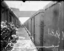
| Date: | 1907 |
|---|---|
| Description: | View down platform of train stopped at a loading dock at International Harvester's Osborne Works (later known as Auburn Works). On the dock is a large stac... |

| Date: | 1907 |
|---|---|
| Description: | Several men are standing and posing next to a large pit. The men, dressed in work clothes, are equipped with shovels. There is a truck backed up to the pit... |

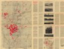
| Date: | 1907 |
|---|---|
| Description: | Shows post offices, railroads, country clubs, and land ownership by name. |
| Date: | 1907 |
|---|---|
| Description: | "Lands colored in red owned and for sale by J.L. Gates Land Company, Milwaukee, Wis." Also shows wagon roads, railroads, schools, and settlers. On verso: M... |

| Date: | 1907 |
|---|---|
| Description: | Shows roads, railroads, lakes, rivers, churches, and camps. |

| Date: | 1907 |
|---|---|
| Description: | Shows post offices, railroads, country clubs, and land ownership by name. Also shows the cities of Lake Geneva and Delavan and Lake Como. "Suggestions for ... |

| Date: | 1907 |
|---|---|
| Description: | Shows public buildings, hotels, fraternity houses, and private houses. Index of fraternities and sororities, residences, public buildings, hotels, places o... |
| Date: | 1907 |
|---|---|
| Description: | A map of Lake Geneva and Lake Delavan, including Lake Como. |
| Date: | 1907 |
|---|---|
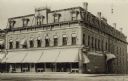
| Description: | Exterior view from street of the stone hotel on a corner. Large awnings are over the first floor windows. Decorative ironwork is on the roof. Caption reads... |
| Date: | 1907 |
|---|---|
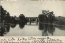
| Description: | View over water towards a railroad bridge over a river. Trees and shrubs are along the banks of the river. There are buildings in the distance behind the b... |

| Date: | 1907 |
|---|---|
| Description: | Colorized postcard view from street of the Catholic Church and Parsonage on a tree-lined street in a residential neighborhood. Caption reads: "Catholic Chu... |
| Date: | 1907 |
|---|---|
| Description: | Photographic postcard view across street towards the Herman Smith Saloon storefront, with a man and two dogs on the sidewalk in front. A horse and buggy ar... |
| Date: | 1907 |
|---|---|
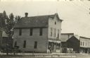
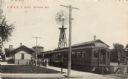
| Description: | Photographic postcard view of the depot and train with passengers on the platform. A large windmill is in the background. Caption reads: "C. M. & St. P. De... |
| Date: | 1907 |
|---|---|
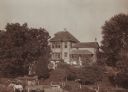
| Description: | Farm home of Thomas Convey family, at or near Ridgeway. In the foreground, two men stand near a horse-drawn wagon. Five women are standing on a stone wall ... |

| Date: | 1907 |
|---|---|
| Description: | This map of Superior and the vicinity shows selected company properties, railroads, and roads in a portion of Douglas County. The map reads: "Copyrighted 1... |
If you didn't find the material you searched for, our Library Reference Staff can help.
Call our reference desk at 608-264-6535 or email us at: