 Filter: Categories of Wisconsin Historical Images
Filter: FULL_DATE of 1909
Filter: Subject of land use, rural
Filter: Categories of Wisconsin Historical Images
Filter: FULL_DATE of 1909
Filter: Subject of land use, rural
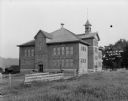
| Date: | 1909 |
|---|---|
| Description: | Exterior view of the public school. A large brick building with a bell tower on the roof, arched entrances, and a wooden fence along the side. |
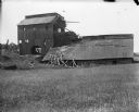
| Date: | 1909 |
|---|---|
| Description: | Exterior view across field of mill and store at Black Hawk. There are feed sacks on the porch of the mill, and a horse is on the far right. |
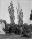
| Date: | 1909 |
|---|---|
| Description: | View of two Lombardy poplar trees next to a stone building. |

| Date: | 1909 |
|---|---|
| Description: | Exterior view of the Harrisburg Church. There are long hills in the background. |
| Date: | 1909 |
|---|---|
| Description: | A deteriorating mining building seen from across a field. |
| Date: | 1909 |
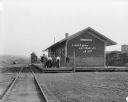
|---|---|
| Description: | View from railroad tracks of a group of six people standing on the platform of the Chicago, Milwaukee and St. Paul depot. Beyond the depot is a water tower... |
| Date: | 1909 |
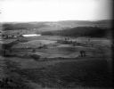
|---|---|
| Description: | The view from Gibraltar Rock across farm fields and woods. There are corn shocks in several of the fields. A farm house and outbuildings stand near a pond... |
| Date: | 1909 |
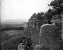
|---|---|
| Description: | Side view of a woman sitting on a rock ledge on the face of Gibraltar Rock bluff. Hills, fields and the Wisconsin River are visible far below in the backgr... |
| Date: | 1909 |
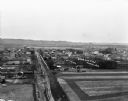
|---|---|
| Description: | An elevated view of a town in the Wisconsin River Valley. Fields surround the town, and low hills are in the far background. |
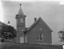
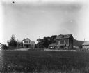
| Date: | 1909 |
|---|---|
| Description: | Exterior of church on hill with arched French doors and a steeple. |

| Date: | 1909 |
|---|---|
| Description: | Postcard distributed by International Harvester Company featuring a color illustration of a harvesting scene in India: men and women working in fields. Ori... |

| Date: | 1909 |
|---|---|
| Description: | Postcard distributed by International Harvester Company depicting a harvesting scene in Algiers. Includes a color illustration of a horse-drawn grain binde... |

| Date: | 1909 |
|---|---|
| Description: | This is one of a set of two topographical maps showing land use, roads, railroads, bridges, and buildings with ownership in parts of LaFayette, Greenfield,... |

| Date: | 1909 |
|---|---|
| Description: | This the second of a set of two topographical maps showing land use, roads, railroads, bridges, and buildings with ownership in parts of LaFayette, Greenfi... |

| Date: | 1909 |
|---|---|
| Description: | View down dirt road leading to the left, with a log cabin to the right among trees. There is a farm implement near the road. Caption reads: "At the Ranch."... |
If you didn't find the material you searched for, our Library Reference Staff can help.
Call our reference desk at 608-264-6535 or email us at:
