 Filter: Categories of Wisconsin Historical Images
Filter: FULL_DATE of 1909
Filter: Subject of sawmills
Filter: Categories of Wisconsin Historical Images
Filter: FULL_DATE of 1909
Filter: Subject of sawmills

| Date: | 1909 |
|---|---|
| Description: | A map of Langlade County, Wisconsin that shows townships and ranges, towns, cities and villages, wagon roads, churches, schools, sawmills, town halls, chee... |

| Date: | 1909 |
|---|---|
| Description: | This 1909 map of Taylor County, Wisconsin, shows the township and range grid, towns, sections, cities and villages, settlers houses, schools, churches, saw... |
| Date: | 1909 |
|---|---|
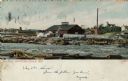
| Description: | Colorized view of Big Mill, a lumber sawmill on the Chippewa river, next to a churning rapids. In the foreground are loose logs, whitewater, river boulders... |

| Date: | 1909 |
|---|---|
| Description: | This map shows vacant Wisconsin Central Ry. lands, settlers houses, lands sold by Wisconsin Central Ry., schools, churches, saw mills, and roads; also show... |

| Date: | 1909 |
|---|---|
| Description: | This map covers Iron and Price Counties and portions of Sawyer and Oneida Counties. The map shows vacant and sold Wis. Central Ry. land, settlers houses, s... |
| Date: | 1909 |
|---|---|
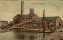
| Description: | View of a sawmill next to a river. Conveyor ramps are leading into the building. Caption reads: "Saw Mill, Marinette, Wis." |
| Date: | 1909 |
|---|---|
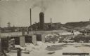
| Description: | Text on front reads: "Brooks & Ross Sawmill & Dam, Schofield, Wis. 1909." The dam and millpond with the sawmill behind it. There are multiple buildings wit... |
If you didn't find the material you searched for, our Library Reference Staff can help.
Call our reference desk at 608-264-6535 or email us at: