 Filter: Categories of Wisconsin Historical Images
Filter: FULL_DATE of 1911
Filter: Subject of architecture
Filter: Type of Map or Atlas
Filter: Categories of Wisconsin Historical Images
Filter: FULL_DATE of 1911
Filter: Subject of architecture
Filter: Type of Map or Atlas

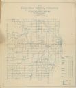
| Date: | 1911 |
|---|---|
| Description: | This 1911 map shows the Post Office's rural routes in Racine County, Wisconsin, and portions of eastern Walworth and northern Kenosha counties. The locatio... |

| Date: | 1911 |
|---|---|
| Description: | This 1911 map from the U.S. Post Office Dept. shows rural delivery routes, active and discontinued post offices, selected rural landowners and houses, chur... |

| Date: | 1911 |
|---|---|
| Description: | This 1911 map from the U.S. Post Office Dept. shows rural delivery routes, active and discontinued post offices, collection boxes, selected rural landowner... |

| Date: | 1911 |
|---|---|
| Description: | Blue line print. Shows post offices, houses, schools, churches, roads, routes, rivers, and railroads. Includes explanation of symbols. "H.G.M. October 12,... |
| Date: | 1911 |
|---|---|
| Description: | Shows routes, post offices, churches, houses, schools, roads, and collection boxes. "B. Oct. 11, 1911." Blue line print. "Sheboygan Co., Wis. 587." |

| Date: | 1911 |
|---|---|
| Description: | This 1911 map from the U.S. Post Office Department shows rural delivery routes, active and discontinued post offices, selected rural landowners and houses,... |

| Date: | 1911 |
|---|---|
| Description: | Shows roads, railroads, post offices, schools, houses, churches, and routes. Includes distant chart and explanation. "Price 35 cents"--Upper left margin. "... |
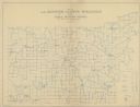
| Date: | 1911 |
|---|---|
| Description: | Map shows routes, post offices, houses, churches, schools, and roads of La Fayette County rural delivery service. The map margins read: "G. January 11, 191... |
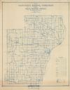
| Date: | 1911 |
|---|---|
| Description: | Shows routes, post offices, schools, churches, houses, roads, and collection boxes of the rural delivery service of Manitowoc County. Bottom margins read:... |

| Date: | 1911 |
|---|---|
| Description: | Map shows in blue roads, railroads, post offices, schools, houses, churches, and routes. The map includes a chart of "Explanation" that acts as a legend. T... |

| Date: | 1911 |
|---|---|
| Description: | This map of Duluth and Superior shows street car routes, railroads, ferries, some points of interest, and lighthouses. The bottom left of the map reads: "C... |

| Date: | 1911 |
|---|---|
| Description: | This map shows ward numbers, streets, railroads, electric car lines, parks, steam railways, section numbers, Lake Michigan and one mile concentric circles ... |
If you didn't find the material you searched for, our Library Reference Staff can help.
Call our reference desk at 608-264-6535 or email us at:
