 Filter: Categories of Wisconsin Historical Images
Filter: FULL_DATE of 1911
Filter: Subject of cities and towns
Filter: Categories of Wisconsin Historical Images
Filter: FULL_DATE of 1911
Filter: Subject of cities and towns

| Date: | 1911 |
|---|---|
| Description: | This map, taken from the 1911 Map of Wisconsin showing geology and roads by Hotchkiss and Thwaites, shows the northwest portion of Douglas County, Wisconsi... |

| Date: | 1911 |
|---|---|
| Description: | This 1911 map of the geology of northern Wisconsin between Superior and Hurley was published by the Wisconsin Geological and Natural History Survey in Fred... |
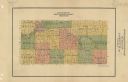
| Date: | 1911 |
|---|---|
| Description: | Map shows townships and sections, roads, and railroads. "W.W. Downs, attorney-at-law, Eau Claire, Wis." |

| Date: | 1911 |
|---|---|
| Description: | This 1911 map from the U.S. Post Office Dept. shows rural delivery routes, active and discontinued post offices, selected rural landowners and houses, chur... |

| Date: | 1911 |
|---|---|
| Description: | This 1911 map from the U.S. Post Office Dept. shows rural delivery routes, active and discontinued post offices, collection boxes, selected rural landowner... |

| Date: | 1911 |
|---|---|
| Description: | This 1911 map from the U.S. Post Office Department shows rural delivery routes, active and discontinued post offices, selected rural landowners and houses,... |

| Date: | 1911 |
|---|---|
| Description: | This hand-colored map is a 1911 copy of a map drawn by Gaspard-Joseph Chaussegros de Léry in 1730 showing the Fox River from its mouth at Green Bay to Lake... |

| Date: | 1911 |
|---|---|
| Description: | Shows roads, railroads, post offices, schools, houses, churches, and routes. Includes distant chart and explanation. "Price 35 cents"--Upper left margin. "... |

| Date: | 1911 |
|---|---|
| Description: | A view looking up King Street from Butler Street toward the Wisconsin State Capitol. It appears there is work being done on the dome. |

| Date: | 1911 |
|---|---|
| Description: | Map printed in the Milwaukee Herald, 16th of February, 1912. Includes list of Assembly, State Senate, and Congressional districts in bottom margin. Contain... |
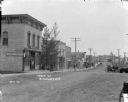
| Date: | 1911 |
|---|---|
| Description: | A downhill view of Main Street with a shoe store and other buildings on the left. Some homes and a church in the distance. Horses and wagons in the street ... |
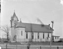
| Date: | 1911 |
|---|---|
| Description: | View across road of the Catholic church. Images of saints are in the stained glass windows along the side. There is a large belfry near the front entrance.... |
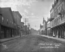
| Date: | 1911 |
|---|---|
| Description: | View down middle of street in a commercial business district. A bakery, a doctor's office and a grocery are on the left. The Opera House, another doctor's ... |
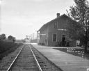
| Date: | 1911 |
|---|---|
| Description: | View down railroad tracks towards the South Wayne depot, with an oncoming train in the distance. Railroad cars are parked on tracks behind the depot. On th... |

| Date: | 1911 |
|---|---|
| Description: | View down center of Main Street. On the left is the Hotel Lewis, with a columned porch and awnings above the second-story windows. Further down the street ... |

| Date: | 1911 |
|---|---|
| Description: | View of Main Street from its intersection with Oak Street. On the left corner is a bank and two drug stores. On the right are two restaurants and a shoe sh... |

| Date: | 1911 |
|---|---|
| Description: | View from street of the Carnegie Library. A boy is standing on the stone steps that lead up to the arched entrance which has two round windows and a datest... |

| Date: | 1911 |
|---|---|
| Description: | The Auditorium Hotel, a three-story building with a turret and stairs to the main floor entrances. A wrap-around balcony is on the main floor. Barrels unde... |

| Date: | 1911 |
|---|---|
| Description: | View across street of the German Lutheran Church. There is a lamppost and a sign at the foot of the stairs. A fenced-in churchyard is on the right. The par... |

| Date: | 1911 |
|---|---|
| Description: | View across street of the M.E. Church, which is a one-story wood frame building with a weather vane on the steeple. There are tall windows on either side o... |
If you didn't find the material you searched for, our Library Reference Staff can help.
Call our reference desk at 608-264-6535 or email us at: