Filter: Categories of Wisconsin Historical Images
Filter: FULL_DATE of 1912
Filter: Type of Map or Atlas
Filter: Creator Name of Unknown
Filter: Categories of Wisconsin Historical Images
Filter: FULL_DATE of 1912
Filter: Type of Map or Atlas
Filter: Creator Name of Unknown

| Date: | 1912 |
|---|---|
| Description: | A map shows the Presbyterian churches, presbyteries, and districts in Wisconsin, as well as the counties, the locations cities and towns in the state. Indi... |

| Date: | 1912 |
|---|---|
| Description: | This outline map of Sauk County, Wisconsin, shows the towns, cities and villages, railroads, and streams in the county. |

| Date: | 1912 |
|---|---|
| Description: | This manuscript blueprint map shows numbered buildings and manuscript annotations. Lake Mendota and streets are labeled. |

| Date: | 1912 |
|---|---|
| Description: | This manuscript blueprint map shows land conditions for future construction development on the University of Wisconsin-Madison campus. It highlights roads ... |

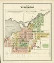
| Date: | 1912 |
|---|---|
| Description: | A plat map of the township of West Kewaunee. |

| Date: | 1912 |
|---|---|
| Description: | A plat map of the township of Casco. Created by Geo. A. Ogle. |
If you didn't find the material you searched for, our Library Reference Staff can help.
Call our reference desk at 608-264-6535 or email us at: