 Filter: Categories of Wisconsin Historical Images
Filter: FULL_DATE of 1912
Filter: Type of Map or Atlas
Filter: Subject of land
Filter: Categories of Wisconsin Historical Images
Filter: FULL_DATE of 1912
Filter: Type of Map or Atlas
Filter: Subject of land
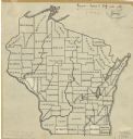
| Date: | 1912 |
|---|---|
| Description: | An ink and pencil on paper map of Wisconsin that shows contemporary county divisions in the state. The map depicts the locations of some of the rivers that... |

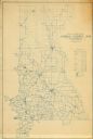
| Date: | 1912 |
|---|---|
| Description: | This map is pen, ink, and pencil on tracing paper. The map was traced from U.S. Geological Survey map of Wisconsin, compiled in 1910-1911, and printed in 1... |
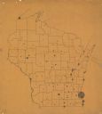
| Date: | 1912 |
|---|---|
| Description: | This map is pen and ink on paper. The map was traced from a more detailed population dot map, this map shows only the major towns and cities in southern Wi... |

| Date: | 1912 |
|---|---|
| Description: | A map of Monroe County, Wisconsin showing townships, the towns of Sparta, Tomah, Oakdale, Wilton, Cashton, Glendale, Kendall and Wyeville, as well as the U... |

| Date: | 1912 |
|---|---|
| Description: | This outline map of Sauk County, Wisconsin, shows the towns, cities and villages, railroads, and streams in the county. |

| Date: | 1912 |
|---|---|
| Description: | This early 20th century map of Barron County, Wisconsin, shows the township and range grid, towns, sections, cities and villages, railroads, roads, houses,... |
| Date: | 1912 |
|---|---|
| Description: | Map shows roads, railroads, post offices, schools, houses, churches, routes, and post office collection boxes. The map includes a distant chart and explana... |

| Date: | 1912 |
|---|---|
| Description: | This map shows a school reserve, swamp land, railroads, and selected buildings. |

| Date: | 1912 |
|---|---|
| Description: | This blueprint manuscript map shows selected buildings, roads, and the Peshtigo River. |

| Date: | 1912 |
|---|---|
| Description: | Marinette County, Township 36 N., Range 19 E. |

| Date: | 1912 |
|---|---|
| Description: | Marinette plat map, Township 37 N., Range 19 E. |

| Date: | 1912 |
|---|---|
| Description: | Marinette County, Township 36 N., Range 20 E. |

| Date: | 1912 |
|---|---|
| Description: | Marinette County, Township 37 N., Range 20 E. |

| Date: | 1912 |
|---|---|
| Description: | Marinette County, Fract. Township 36 N., Ranges 21 and 22 E. |

| Date: | 1912 |
|---|---|
| Description: | Marinette County, Fract. Township 37 N., Ranges 21 and 22 E. |

| Date: | 1912 |
|---|---|
| Description: | A portion of a plat map of Marinette County showing township 30 N., range 21 E., and part of township 29 N., range 21 E. |

| Date: | 1912 |
|---|---|
| Description: | A plat map of the township of West Kewaunee. |

| Date: | 1912 |
|---|---|
| Description: | A plat map of the township of Casco. Created by Geo. A. Ogle. |
If you didn't find the material you searched for, our Library Reference Staff can help.
Call our reference desk at 608-264-6535 or email us at: