 Filter: Categories of Wisconsin Historical Images
Filter: FULL_DATE of 1913
Filter: Community of Madison
Filter: Subject of human settlements
Filter: Categories of Wisconsin Historical Images
Filter: FULL_DATE of 1913
Filter: Community of Madison
Filter: Subject of human settlements
| Date: | 1913 |
|---|---|
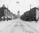
| Description: | View looking up the 200 block of State Street from West Johnson Street, showing the Wisconsin State Capitol dome under construction. The bank on the left i... |
| Date: | 1913 |
|---|---|
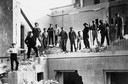
| Description: | Workmen stand atop and in front of the remnants of the last remaining wing, the North Wing, of the third Wisconsin State Capitol building. |
| Date: | 1913 |
|---|---|
| Description: | Workmen demolishing the North Wing of the third Wisconsin State Capitol. Because the North Wing escaped damage during the fire in 1904, the North Wing cont... |

| Date: | 1913 |
|---|---|
| Description: | Horse-drawn American Express wagons in front of the Chicago & Northwestern Railroad Depot. |
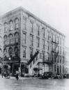
| Date: | 1913 |
|---|---|
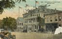
| Description: | West side of Monona Avenue (Martin L. King Jr. Boulevard), with Elks Lodge No. 410, 120 -24 Monona Avenue; GAR Hall, 118 Monona Avenue; Monona Hotel, 114 M... |

| Date: | 1913 |
|---|---|
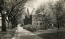
| Description: | View down tree-lined Langdon Street and the lower campus of the University of Wisconsin. Caption reads: "Langdon Street through lower campus, University of... |
| Date: | 1913 |
|---|---|
| Description: | A.O. Fox Block on the corner of Main Street and Carroll Street. |
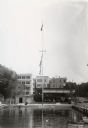
| Date: | 1913 |
|---|---|
| Description: | Mendota Yacht Club, later the site of James Madison Park. A mast with flags is standing outside of the club near the water. |

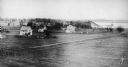
| Date: | 1913 |
|---|---|
| Description: | Panoramic view of Tenney Park showing Marston Bridge. |
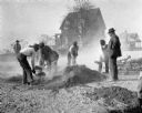
| Date: | 1913 |
|---|---|
| Description: | Street construction at the corner of Regent and Roby Road in Madison. The home of the photographer, W.H. Dudley, is in the background |
| Date: | 1913 |
|---|---|
| Description: | Dudgeon neighborhood looking across Monroe Street to Lake Wingra with Knickerbocker Ice house (1895-1937) in background. Houses identified from left are 62... |

| Date: | 1913 |
|---|---|
| Description: | View across street of the exterior of the Royal Theater, 407 Atwood Avenue (address now 2142 Atwood). Designed by Ferdinand Kronenberg (?) Building remode... |
| Date: | 1913 |
|---|---|
| Description: | View looking southwest at the University Heights neighborhood from near the corner of University Avenue and Breese Terrace. In the foreground is the Univer... |

| Date: | 1913 |
|---|---|
| Description: | Exterior view of hall from across University Avenue on the University of Wisconsin-Madison campus. A sign reading "stop" hangs above the street. |
| Date: | 1913 |
|---|---|
| Description: | View down Bascom Hill of building on University of Wisconsin-Madison campus. |

| Date: | 1913 |
|---|---|
| Description: | This map shows city wards and government buildings. The map is oriented with north to upper right. |
| Date: | 1913 |
|---|---|
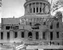
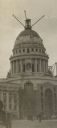
| Description: | View from street of scaffolding and cranes on the Wisconsin State Capitol used to construct the building. Pedestrians and a carriage are in the foreground. |

| Date: | 1913 |
|---|---|
| Description: | This photocopy map shows plots with owners' names, land use both commercial and agricultural, and lot outlines on University land. Lake Mendota is labeled ... |

| Date: | 1913 |
|---|---|
| Description: | Exterior view of a hospital building on a hill. Caption reads: "Madison Sanitarium, Madison, Wis." |
If you didn't find the material you searched for, our Library Reference Staff can help.
Call our reference desk at 608-264-6535 or email us at: