 Filter: Categories of Wisconsin Historical Images
Filter: FULL_DATE of 1913
Filter: Community of Madison
Filter: Subject of transportation
Filter: Subject of streets
Filter: Categories of Wisconsin Historical Images
Filter: FULL_DATE of 1913
Filter: Community of Madison
Filter: Subject of transportation
Filter: Subject of streets
| Date: | 1913 |
|---|---|
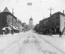
| Description: | View looking up the 200 block of State Street from West Johnson Street, showing the Wisconsin State Capitol dome under construction. The bank on the left i... |
| Date: | 1913 |
|---|---|
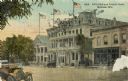
| Description: | West side of Monona Avenue (Martin L. King Jr. Boulevard), with Elks Lodge No. 410, 120 -24 Monona Avenue; GAR Hall, 118 Monona Avenue; Monona Hotel, 114 M... |

| Date: | 1913 |
|---|---|
| Description: | View down tree-lined Langdon Street and the lower campus of the University of Wisconsin. Caption reads: "Langdon Street through lower campus, University of... |

| Date: | 1913 |
|---|---|
| Description: | Panoramic view of Tenney Park showing Marston Bridge. |

| Date: | 1913 |
|---|---|
| Description: | View across street of the exterior of the Royal Theater, 407 Atwood Avenue (address now 2142 Atwood). Designed by Ferdinand Kronenberg (?) Building remode... |

| Date: | 1913 |
|---|---|
| Description: | This map shows city wards and government buildings. The map is oriented with north to upper right. |

| Date: | 1913 |
|---|---|
| Description: | This photocopy map shows plots with owners' names, land use both commercial and agricultural, and lot outlines on University land. Lake Mendota is labeled ... |
| Date: | 1913 |
|---|---|
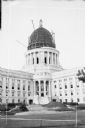
| Description: | View across street towards temporary derricks protruding from the steel framework of the dome on the Wisconsin State Capitol. The lantern cage tops the dom... |
If you didn't find the material you searched for, our Library Reference Staff can help.
Call our reference desk at 608-264-6535 or email us at: