 Filter: Categories of Wisconsin Historical Images
Filter: FULL_DATE of 1913
Filter: Subject of transportation
Filter: Categories of Wisconsin Historical Images
Filter: FULL_DATE of 1913
Filter: Subject of transportation
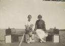
| Date: | 1913 |
|---|---|
| Description: | Two people sitting on a boat. Identified on back as Betty Bishop and Wallace? Wallace is wearing a baseball mitt on his left hand. |
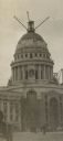
| Date: | 1913 |
|---|---|
| Description: | View from street of scaffolding and cranes on the Wisconsin State Capitol used to construct the building. Pedestrians and a carriage are in the foreground. |
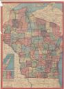
| Date: | 1913 |
|---|---|
| Description: | This map shows automobile roads, cities, county boundaries, rivers, lakes, railroads, electric lines, and congressional districts. Included are portions of... |
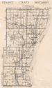
| Date: | 1913 |
|---|---|
| Description: | This map shows landownership, rural mail routes, rural buildings, railroads, U.S. national highways, state trunk highways, county trunk highways, township... |

| Date: | 1913 |
|---|---|
| Description: | Hand-colored view of a footbridge crossing over Cedar Creek. A man is fishing from the bridge, and a dog is standing nearby. Two boys are sitting in the gr... |
| Date: | 1913 |
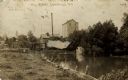
|---|---|
| Description: | Photographic postcard view of the mill and creek, with a bridge in front of the mill. The skyline of Centerville is in the background. Caption reads: "Mill... |
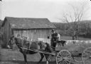
| Date: | 1913 |
|---|---|
| Description: | View across yard towards Carl Peterson sitting next to his son James holding the reins of two horses while sitting on a wagon. In the background are farm b... |

| Date: | 1913 |
|---|---|
| Description: | This photocopy map shows plots with owners' names, land use both commercial and agricultural, and lot outlines on University land. Lake Mendota is labeled ... |

| Date: | 1913 |
|---|---|
| Description: | This map details automobile routes throughout the state and parts of Illinois, Minnesota, Michigan, and Iowa. Cities, counties, Lake Michigan, Lake Superio... |

| Date: | 1913 |
|---|---|
| Description: | This map displays automobile routes across Wisconsin as well as Minnesota, Iowa, Michigan and Illinois. Cities, counties, Lake Michigan, Lake Superior, Gre... |
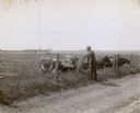
| Date: | 1913 |
|---|---|
| Description: | Professor Holden standing near a road and feeding alfalfa to cows over a fence. The cows are running on splendid blue-grass pasture, but they are eager for... |
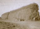
| Date: | 1913 |
|---|---|
| Description: | Four men posing near a large, tall stack of alfalfa. One man is sitting in an automobile. The ricks of alfalfa are on the Swartz Brothers' Cornfalfa Farm i... |
| Date: | 1913 |
|---|---|
| Description: | Colorized view of the courthouse behind several trees. A flag is flying above the entrance, and horse-drawn buggies are parked in front. Caption reads: "Co... |
| Date: | 1913 |
|---|---|
| Description: | Colorized postcard view across street towards the Chippewa Valley Bank on a street corner. A Model T is parked along the curb in front. Caption reads: "Chi... |
| Date: | 1913 |
|---|---|
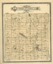
| Description: | A plat map of the township of Norwood in Langlade County. |
| Date: | 1913 |
|---|---|
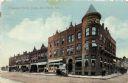
| Description: | Hand-colored scene of north Main Street lined with businesses. There are horse-drawn vehicles in the unpaved street. Caption reads: "N. Main Street, Ft. At... |

| Date: | 1913 |
|---|---|
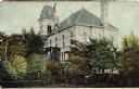
| Description: | View across road toward the high school which has a bell tower. Caption reads: "High School, Fort Atkinson, Wis." |
| Date: | 1913 |
|---|---|
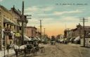
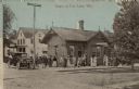
| Description: | View across railroad tracks towards the railroad depot, with several passengers standing on the platform. An automobile is parked at the curb. Caption read... |

| Date: | 1913 |
|---|---|
| Description: | Hand-colored view of Grand Avenue looking east toward the bridge. The street is lined with businesses. Caption reads: "Grand Avenue Looking East, Grand Rap... |

| Date: | 1913 |
|---|---|
| Description: | View from shoreline towards a stone pedestrian bridge on a river. The city skyline is in the distance. Caption reads: "Strollers Bridge, Grand Rapids, Wis.... |
If you didn't find the material you searched for, our Library Reference Staff can help.
Call our reference desk at 608-264-6535 or email us at: