 Filter: Categories of Wisconsin Historical Images
Filter: FULL_DATE of 1914
Filter: Subject of cemeteries
Filter: Categories of Wisconsin Historical Images
Filter: FULL_DATE of 1914
Filter: Subject of cemeteries
| Date: | 1914 |
|---|---|
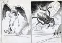
| Description: | Illustration made for International Harvester's Agricultural Extension Department to demonstrate the danger of pests, including diseases carried by insects... |
| Date: | 1914 |
|---|---|
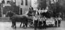
| Description: | Boilermakers and their helpers pose on and around a horse-drawn wagon that bears a sign that reads "Boiler-makers and Helpers," perhaps for a parade. Man o... |

| Date: | 1914 |
|---|---|
| Description: | Plat book of Waukesha County. Pages 14 - 15. |

| Date: | 1914 |
|---|---|
| Description: | A hand-drawn and colored map of the Milwaukee Township, showing how lands were used, included are parks, cemeteries, private grounds, and speculative land.... |

| Date: | 1914 |
|---|---|
| Description: | Map shows school houses, creameries, post offices, saw mills, grist mills, churches, cemeteries, town halls, stores, roads, state roads, and railroads. "Co... |

| Date: | 1914 |
|---|---|
| Description: | Shows land ownership by name, rural routes, improved roads, railroads, schools, churches, and cemeteries. "For list of small property owners, lift map at f... |

| Date: | 1914 |
|---|---|
| Description: | View towards a wooden fence surrounding a cemetery near Tom Lake, north of Chicago Bay. Wooded hills are in the background. |

| Date: | 1914 |
|---|---|
| Description: | Pg. 44 West Half of Marion Township. Pg. 45 East Half of Marion Township. |
If you didn't find the material you searched for, our Library Reference Staff can help.
Call our reference desk at 608-264-6535 or email us at: