 Filter: Categories of Wisconsin Historical Images
Filter: FULL_DATE of 1914
Filter: Subject of cities and towns
Filter: Type of Map or Atlas
Filter: Categories of Wisconsin Historical Images
Filter: FULL_DATE of 1914
Filter: Subject of cities and towns
Filter: Type of Map or Atlas

| Date: | 1914 |
|---|---|
| Description: | This map shows Sheboygan in 1914. The top of the map has the date of "NOV 17 1916" stamped in red ink. The map shows numbered plots and labeled streets, an... |

| Date: | 1914 |
|---|---|
| Description: | Atlas and farm directory of the Washara County containing Plats of all the Townships with Owners' Names; also Maps of the State, United States and World; a... |
| Date: | 1914 |
|---|---|
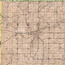
| Description: | The Verona township, a detail of the Dane County, Wisconsin map of land ownership. |

| Date: | 1914 |
|---|---|
| Description: | Plat book of Waukesha County. Pages 14 - 15. |

| Date: | 1914 |
|---|---|
| Description: | North part of Waukesha County. From Atlas of Waukesha County. Pages 10 - 11. |

| Date: | 1914 |
|---|---|
| Description: | Two maps of northern Wisconsin counties of Ashland, Barron, Bayfield, Chippewa, Douglas, Forest, Iron, Langlade, Lincoln, Oneida, Polk, Price, Sawyer, Tayl... |

| Date: | 1914 |
|---|---|
| Description: | A hand-colored map of Wisconsin showing the locations of cities and towns, counties, railway lines, the steamship lines in Lake Superior and lake Michigan.... |

| Date: | 1914 |
|---|---|
| Description: | A business atlas map of Wisconsin, showing the railroads, counties, cities, villages, rivers, lakes, electric lines, and steamship lines in the state. Othe... |

| Date: | 1914 |
|---|---|
| Description: | A hand-drawn and colored map of the Milwaukee Township, showing how lands were used, included are parks, cemeteries, private grounds, and speculative land.... |

| Date: | 1914 |
|---|---|
| Description: | This map of Price County, Wisconsin, from the early 20th century shows land for sale by the Homemaker Land Company of Milwaukee. The township and range sys... |

| Date: | 1914 |
|---|---|
| Description: | This 1914 map of Price County, Wisconsin, shows land for sale by the Good Land Company and Dewitt van Ostrand of Phillips. Also shown are the township and ... |

| Date: | 1914 |
|---|---|
| Description: | This early 20th century map shows the township and range system, sections, railroads, roads, lakes, wetlands, and streams in the western Sawyer County town... |

| Date: | 1914 |
|---|---|
| Description: | This 1914 map shows the soil types in Vilas County, Wisconsin, and adjoining areas in Oneida, Forest, and Iron counties. Also depicted are the township and... |

| Date: | 1914 |
|---|---|
| Description: | This early-20th century map of Clark County, Wisconsin, shows the township and range grid, sections, cities and villages, wagon roads, railroads, settlers,... |
| Date: | 1914 |
|---|---|
| Description: | This early-20th century map of Clark County, Wisconsin, shows the township and range grid, towns, sections, cities and villages, property owners and acreag... |

| Date: | 1914 |
|---|---|
| Description: | This 1914 map of Douglas County, Wisconsin, shows the township and range grid, towns, sections, cities and villages, roads, railroads, Indian trails, schoo... |

| Date: | 1914 |
|---|---|
| Description: | Map shows school houses, creameries, post offices, saw mills, grist mills, churches, cemeteries, town halls, stores, roads, state roads, and railroads. "Co... |

| Date: | 1914 |
|---|---|
| Description: | Shows land ownership by name, rural routes, improved roads, railroads, schools, churches, and cemeteries. "For list of small property owners, lift map at f... |

| Date: | 1914 |
|---|---|
| Description: | Shows lot numbers and dimensions; covers portion of the neighborhood currently known as Shorewood Hills. Includes red annotations showing houses and sold l... |

| Date: | 1914 |
|---|---|
| Description: | Map shows townships, schools, saw mills, roads, railroads, and post offices. Text on the top left has a box of towns with land in Marathon County. Top righ... |
If you didn't find the material you searched for, our Library Reference Staff can help.
Call our reference desk at 608-264-6535 or email us at: