 Filter: Categories of Wisconsin Historical Images
Filter: FULL_DATE of 1914
Filter: Subject of fortification
Filter: Categories of Wisconsin Historical Images
Filter: FULL_DATE of 1914
Filter: Subject of fortification

| Date: | 1914 |
|---|---|
| Description: | This map is a photostat copy from the original 1829 map in the War Department. The map shows location of Fort Howard, lots, land claims of Jacques Porlier ... |

| Date: | 1914 |
|---|---|
| Description: | This photostat map shows Fort Winnebago around 1931, land to be reserved for military purposes, roads to Fort Howard and Fort Crawford, "private property" ... |
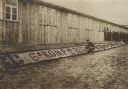
| Date: | 1914 |
|---|---|
| Description: | French PoW's beautifying the exterior of a barracks building in the camp at Zossen. |

| Date: | 1914 |
|---|---|
| Description: | A view of model trenches, built in Berlin by convalescing German soldiers. These were used both for training and for exhibition. |

| Date: | 1914 |
|---|---|
| Description: | Searchlight positioned on a fort in Antwerp in order to light a section of railroad track. Water is in the foreground. |
If you didn't find the material you searched for, our Library Reference Staff can help.
Call our reference desk at 608-264-6535 or email us at: