 Filter: Categories of Wisconsin Historical Images
Filter: FULL_DATE of 1914
Filter: Subject of lakes
Filter: Categories of Wisconsin Historical Images
Filter: FULL_DATE of 1914
Filter: Subject of lakes
| Date: | 1914 |
|---|---|
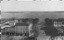
| Description: | Monona Avenue with Lake Monona in the background. (Martin Luther King, Jr. Boulevard as of January 19, 1987). View from the dome of the Wisconsin State Cap... |

| Date: | 1914 |
|---|---|
| Description: | View down pier towards the Yacht Club on shoreline of Lake Winnebago. There is a widow's walk on the roof. Caption reads: "Oshkosh Yacht Club, Oshkosh, Wis... |
| Date: | 1914 |
|---|---|
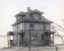
| Description: | The first Madison home of Richard and Georgia Lloyd Jones, 941 Harvey Terrace. He was editor and publisher of the Wisconsin State Journal. Lake Monona is ... |
| Date: | 1914 |
|---|---|
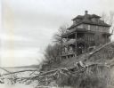
| Description: | Rear view from shoreline of the first Madison home of Richard and Georgia Lloyd Jones, 941 Harvey Terrace, on the north shore of Lake Monona. |

| Date: | 1914 |
|---|---|
| Description: | The first Madison home of Richard Lloyd Jones, 941 Harvey Terrace (now called Rutledge Court), on the north shore of Lake Monona. |

| Date: | 1914 |
|---|---|
| Description: | Armory (Red Gym or Old Red) on Langdon Street, with YMCA (on the left), and Lake Mendota in the background. University of Wisconsin-Madison campus. |

| Date: | 1914 |
|---|---|
| Description: | Armory (Red Gym or Old Red) on Langdon Street on the University of Wisconsin-Madison campus. Lake Mendota is in the background. |

| Date: | 1914 |
|---|---|
| Description: | Colorized postcard of the rock formation called the Devil's Doorway in Devil's Lake State Park. Trees can be seen below. The lake, bluffs, roads and buildi... |

| Date: | 1914 |
|---|---|
| Description: | Colorized postcard of the rock formation called the Stone Face in Devil's Lake State Park. Trees and shrubs can be seen all around. The lake, bluffs and sk... |
| Date: | 1914 |
|---|---|
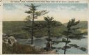
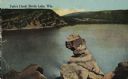
| Description: | Colorized postcard of Devil's Lake. Rock formations are in the foreground. Trees can be seen throughout. Bluffs and sky are visible in the background. The ... |
| Date: | 1914 |
|---|---|
| Description: | Colorized postcard of the rock formation called the Turk's Head in Devil's Lake State Park. The lake, bluffs, trees and sky are visible in the background. ... |

| Date: | 1914 |
|---|---|
| Description: | Two maps of northern Wisconsin counties of Ashland, Barron, Bayfield, Chippewa, Douglas, Forest, Iron, Langlade, Lincoln, Oneida, Polk, Price, Sawyer, Tayl... |

| Date: | 1914 |
|---|---|
| Description: | A hand-colored map of Wisconsin showing the locations of cities and towns, counties, railway lines, the steamship lines in Lake Superior and lake Michigan.... |

| Date: | 1914 |
|---|---|
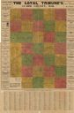
| Description: | A business atlas map of Wisconsin, showing the railroads, counties, cities, villages, rivers, lakes, electric lines, and steamship lines in the state. Othe... |

| Date: | 1914 |
|---|---|
| Description: | This map of Price County, Wisconsin, from the early 20th century shows land for sale by the Homemaker Land Company of Milwaukee. The township and range sys... |

| Date: | 1914 |
|---|---|
| Description: | This 1914 map of Price County, Wisconsin, shows land for sale by the Good Land Company and Dewitt van Ostrand of Phillips. Also shown are the township and ... |

| Date: | 1914 |
|---|---|
| Description: | This early 20th century map shows the township and range system, sections, railroads, roads, lakes, wetlands, and streams in the western Sawyer County town... |

| Date: | 1914 |
|---|---|
| Description: | This 1914 map shows the soil types in Vilas County, Wisconsin, and adjoining areas in Oneida, Forest, and Iron counties. Also depicted are the township and... |
| Date: | 1914 |
|---|---|
| Description: | This early-20th century map of Clark County, Wisconsin, shows the township and range grid, towns, sections, cities and villages, property owners and acreag... |

| Date: | 1914 |
|---|---|
| Description: | This 1914 map of Douglas County, Wisconsin, shows the township and range grid, towns, sections, cities and villages, roads, railroads, Indian trails, schoo... |
If you didn't find the material you searched for, our Library Reference Staff can help.
Call our reference desk at 608-264-6535 or email us at: