 Filter: Categories of Wisconsin Historical Images
Filter: FULL_DATE of 1914
Filter: Subject of michigan, lake
Filter: Categories of Wisconsin Historical Images
Filter: FULL_DATE of 1914
Filter: Subject of michigan, lake

| Date: | 1914 |
|---|---|
| Description: | This map shows Sheboygan in 1914. The top of the map has the date of "NOV 17 1916" stamped in red ink. The map shows numbered plots and labeled streets, an... |
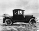
| Date: | 1914 |
|---|---|
| Description: | A 1914 Cadillac sitting near Lake Michigan. Its body was produced by the W.S. Seaman Company. |
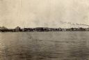
| Date: | 1914 |
|---|---|
| Description: | View of Sturgeon Bay with the Teweles & Brandeis flour mill across the water on the left. |
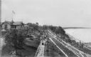
| Date: | 1914 |
|---|---|
| Description: | Elevated view of Pabst Whitefish Bay Resort on the shores of Lake Michigan, with crowds of individuals walking up the numerous paths that lead to the resor... |

| Date: | 1914 |
|---|---|
| Description: | A hand-colored map of Wisconsin showing the locations of cities and towns, counties, railway lines, the steamship lines in Lake Superior and lake Michigan.... |
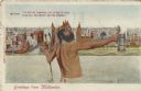
| Date: | 1914 |
|---|---|
| Description: | Postcard of the Milwaukee lakefront. In the foreground is an image of Neptune standing in Lake Michigan holding a trident in one hand and a beer stein in t... |

| Date: | 1914 |
|---|---|
| Description: | A business atlas map of Wisconsin, showing the railroads, counties, cities, villages, rivers, lakes, electric lines, and steamship lines in the state. Othe... |

| Date: | 1914 |
|---|---|
| Description: | A hand-drawn and colored map of the Milwaukee Township, showing how lands were used, included are parks, cemeteries, private grounds, and speculative land.... |

| Date: | 1914 |
|---|---|
| Description: | This map shows counties, roads, Lake Superior, Lake Michigan, and portions of surrounding states. Also included is a list of railroads showing miles and gr... |

| Date: | 1914 |
|---|---|
| Description: | This map shows main traveled routes. Portions of Lake Michigan, Lake Superior, Illinois, Iowa, Michigan and Minnesota are labeled. Also includes a legend s... |
If you didn't find the material you searched for, our Library Reference Staff can help.
Call our reference desk at 608-264-6535 or email us at: