 Filter: Categories of Wisconsin Historical Images
Filter: FULL_DATE of 1916
Filter: Reproduction Rights of For Sale
Filter: Subject of superior, lake
Filter: Categories of Wisconsin Historical Images
Filter: FULL_DATE of 1916
Filter: Reproduction Rights of For Sale
Filter: Subject of superior, lake
| Date: | 1916 |
|---|---|
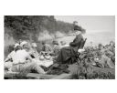
| Description: | Picnic on the shores of Basswood Island, Apostle Islands. Those picnicking include Harriet Webb, C.A. Hull, H.W. Rodgers, Mrs. J. Austin, Elizabeth Baker, ... |
| Date: | 1916 |
|---|---|
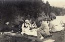
| Description: | Group of people gathered for a rustic picnic on Bear Island, Apostle Islands, Lake Superior. Image includes Mrs. J.L. Abernathy, Cora A. Hull, Mrs F.B. Chu... |
| Date: | 1916 |
|---|---|
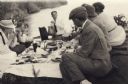
| Description: | Group having a picnic on Bear Island of the Apostle Islands. Group includes Cora A. Hull, Mrs. Chute, John Webb, Bob Webb, Mrs. Webb, Mrs. Austin, and Mr. ... |

| Date: | 1916 |
|---|---|
| Description: | A pen on paper, hand-drawn map that shows the railroads, rivers, county outlines, and cities and villages in Wisconsin, northern Illinois, and the western ... |

| Date: | 1916 |
|---|---|
| Description: | In 1916, it was estimated that 15,000 Indian mounds had formerly existed in Wisconsin. In the early 20th century, the Wisconsin Archaeological Society surv... |

| Date: | 1916 |
|---|---|
| Description: | This 1916 map of Washburn County, Wisconsin, shows the township and range grid, sections, towns, schools, wagon roads, cities and villages, post offices, s... |

| Date: | 1916 |
|---|---|
| Description: | This map is mounted on cloth and shows lots and roads. An inset map is included that shows towns, lakes, rivers, and railroads within portions of the Dakot... |
| Date: | 1916 |
|---|---|
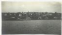
| Description: | View across Lake Superior towards Bayfield. |

| Date: | 1916 |
|---|---|
| Description: | This map shows highways, roads, routes, communities, rivers, and lakes. Wide red lines show principle highways. Narrow red lines show secondary roadways or... |

| Date: | 1916 |
|---|---|
| Description: | This map shows railroads, cities, rivers, lakes, and county boundaries. Select railroads are outlined in red. Portions of western Wisconsin Minnesota are v... |
If you didn't find the material you searched for, our Library Reference Staff can help.
Call our reference desk at 608-264-6535 or email us at: