 Filter: Categories of Wisconsin Historical Images
Filter: FULL_DATE of 1916
Filter: Reproduction Rights of For Sale
Filter: Subject of transportation
Filter: Categories of Wisconsin Historical Images
Filter: FULL_DATE of 1916
Filter: Reproduction Rights of For Sale
Filter: Subject of transportation

| Date: | 1916 |
|---|---|
| Description: | The "St. Paul" was built in 1883 in St. Louis, Missouri for the St. Louis & St. Paul Packet Co., and ran under the Diamond Jo flag. The Eagle Yard in Dubuq... |

| Date: | 1916 |
|---|---|
| Description: | This Wisconsin Conservation Commission map from 1916 shows Peninsula State Park in the Town of Gibraltar, Door County, Wisconsin. Depicted are open and pla... |

| Date: | 1916 |
|---|---|
| Description: | This version of a 1916 Wisconsin Conservation Commission map shows Peninsula State Park in the Town of Gibraltar, Door County, Wisconsin. Depicted are open... |
| Date: | 1916 |
|---|---|
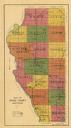
| Description: | This early 20th century map of Adams County, Wisconsin, shows the township and range grid, towns, sections, cities and villages, roads, railroads, lakes an... |

| Date: | 1916 |
|---|---|
| Description: | This 1916 map of Washburn County, Wisconsin, shows the township and range grid, sections, towns, schools, wagon roads, cities and villages, post offices, s... |
| Date: | 1916 |
|---|---|
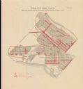
| Description: | Shows streetlights, streets improvements, and sewer districts in red. Points of interest are labelled. Map reads: "Map of Tenth Ward Showing Improvements S... |

| Date: | 1916 |
|---|---|
| Description: | A truck parked in front of an International Harvester Company building, possibly the Champion Works. The building has an archway, with lettering which read... |
| Date: | 1916 |
|---|---|
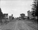
| Description: | View down middle of unpaved street towards six children standing in the middle. There is a storefront on the right, with an automobile and a horse and bugg... |
| Date: | 1916 |
|---|---|
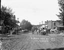
| Description: | View down middle of street, with pedestrians, horses and wagons delivering milk cans. The ridge of a tree-lined hill is in the background. |
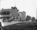
| Date: | 1916 |
|---|---|
| Description: | View across street in a central business district. On the opposite corner is a brick building with a balcony. A man sits in front of a store front on the s... |

| Date: | 1916 |
|---|---|
| Description: | Map shows roads, railroads, the Fox River, parks, and cemeteries. Wards are numbered and the edges of the map feature coordinates. The top left of the map ... |

| Date: | 1916 |
|---|---|
| Description: | This map of Racine includes an indexed street directory, schools, public buildings, parks, directory of buildings, and churches. The map includes 3 illustr... |

| Date: | 1916 |
|---|---|
| Description: | Girl standing on a small town street corner. |

| Date: | 1916 |
|---|---|
| Description: | This map shows Chequamegon Bay, an inlet of Lake Superior. Depths are shown by isolines and soundings and relief shown by contours. The map is colored in y... |

| Date: | 1916 |
|---|---|
| Description: | Water of Big Bull Falls or the Wisconsin River rapidly flows underneath two railroad bridges. Pedestrians cross the bridges while peering over at the over... |

| Date: | 1916 |
|---|---|
| Description: | Hand-colored postcard view from across street towards the Chippewa Falls High School on North Bridge Street. Caption reads: "High School, Chippewa Falls, W... |
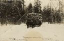
| Date: | 1916 |
|---|---|
| Description: | Black and white photographic postcard of a horse-drawn sled loaded with logs coming out of the woods. One or two men are driving the sled, and a man is wal... |

| Date: | 1916 |
|---|---|
| Description: | Elevated view from hill looking towards Nagawicka Lake. There is a road and buildings along the shoreline at the bottom of the hill. There are a number of ... |

| Date: | 1916 |
|---|---|
| Description: | A black and white photograph of newly paved Madison Road. It was paved in 1916 with asphalt concrete by Jas. Rasmussen & Sons, Oshkosh, Wisconsin, under th... |

| Date: | 1916 |
|---|---|
| Description: | This map is mounted on cloth and shows lots and roads. An inset map is included that shows towns, lakes, rivers, and railroads within portions of the Dakot... |
If you didn't find the material you searched for, our Library Reference Staff can help.
Call our reference desk at 608-264-6535 or email us at: