 Filter: Categories of Wisconsin Historical Images
Filter: FULL_DATE of 1918
Filter: Subject of transportation
Filter: Categories of Wisconsin Historical Images
Filter: FULL_DATE of 1918
Filter: Subject of transportation
| Date: | 1918 |
|---|---|
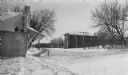
| Description: | Winter scene looking east on Main Street (Highway 42), with wooden commercial buildings on both sides of the street. The building on the left, 4168 Main St... |
| Date: | 1918 |
|---|---|
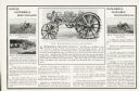
| Description: | Advertisement for the Whitney tractor featuring a side view illustration of the machine at top center with a caption reading: "Tested under the most trying... |
| Date: | 1918 |
|---|---|
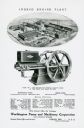
| Description: | Back cover of a pamphlet advertising the Worthington Pump and Machinery Corporation. The advertisement features an illustration of the Ingeco Engine Plant ... |
| Date: | 1918 |
|---|---|
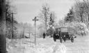
| Description: | A boy holds the door handle of a circa 1916 Model T Ford with a modified radiator cover. A girl walks up the road toward the car. There is a bridge over a ... |
| Date: | 1918 |
|---|---|
| Description: | A road map of Milwaukee and Waukesha counties, that shows the status of roads as being good, completed, new work, proposed, state truck and those receiving... |
| Date: | 1918 |
|---|---|
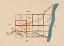
| Description: | This map shows the property owned by Edwin Bottomley and others at the confluence of Eagle Creek with the Fox River in the Town of Rochester, Racine County... |

| Date: | 1918 |
|---|---|
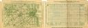
| Description: | This 1918 map of Chippewa County, Wisconsin, shows the township and range grid, towns, sections, cities and villages, rural residences, churches, schools, ... |

| Date: | 1918 |
|---|---|
| Description: | View down street of the central business district. A large brick building on the left with awnings includes a furniture store. Automobiles are parked at an... |
| Date: | 1918 |
|---|---|
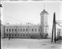
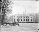
| Description: | Exterior view across plaza of the Archangel District Administration Building. |
| Date: | 1918 |
|---|---|
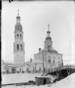
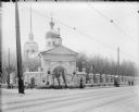
| Description: | Exterior view of the Church of Uspenanski Bogoroditski. This building also served as an American hospital in Archangel [Arkhangelsk], Russia during the All... |
| Date: | 1918 |
|---|---|
| Description: | Exterior of the governor general's house of the U.S. Army's North Russian Expeditionary Force. |
| Date: | 1918 |
|---|---|
| Description: | View across square of the Church of Rojdestva Kristova (Nativity of Christ) near Archangel [Arkhangelsk], Russia. |
| Date: | 1918 |
|---|---|
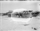
| Description: | Wood sawyers gathering wood and hauling it on a sled pulled by horse near Archangel [Arkhangelsk], Russia. There is a large stack of lumber as well as a pi... |
| Date: | 1918 |
|---|---|
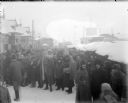
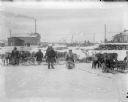
| Description: | Slightly elevated view of a group of men, women, and children standing outdoors and looking towards the camera. They are probably attending the market in A... |
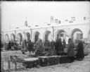
| Date: | 1918 |
|---|---|
| Description: | People wearing thick coats and hats, some made of fur, are standing at an outside market, possibly in Arkhangelsk, Russia. In the background is a long buil... |
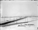
| Date: | 1918 |
|---|---|
| Description: | Tramway and railroad leading into Solombola, Russia. In the foreground are a group of people, some sawing wood and others standing by the railroad. |
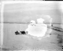
| Date: | 1918 |
|---|---|
| Description: | View across snow of a man driving a sled with a team of reindeer. There are railroad tracks on the right that run towards a town in the distance. A number ... |
| Date: | 1918 |
|---|---|
| Description: | Two men and a young boy pose on sleds near their teams of reindeer in front of a house and its outbuildings. In the background is a large building with oni... |
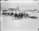
| Date: | 1918 |
|---|---|
| Description: | A family of Laplanders with their reindeer sled teams. In the background are a house with its outhouses, and a group of people to the left of center, as we... |

| Date: | 1918 |
|---|---|
| Description: | Map showing Aleppo, Zor, Syria, Lebanon, Beirut, Jerusalem, with an inset map of the Sinai Peninsula and Egyptian frontier. Also shows the locations of rai... |
If you didn't find the material you searched for, our Library Reference Staff can help.
Call our reference desk at 608-264-6535 or email us at: