Filter: Categories of Wisconsin Historical Images
Filter: FULL_DATE of 1922
Filter: Subject of human settlements
Filter: Categories of Wisconsin Historical Images
Filter: FULL_DATE of 1922
Filter: Subject of human settlements
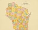
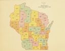
| Date: | 1922 |
|---|---|
| Description: | A map of Wisconsin showing the state’s Assembly Districts. It also provides the population total of each county. |
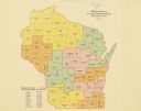
| Date: | 1922 |
|---|---|
| Description: | A map of Wisconsin showing the state’s congressional districts, it also provides the population total for the state, each district and each county. |
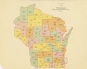
| Date: | 1922 |
|---|---|
| Description: | A map of Wisconsin showing the state’s Senate districts, it also provides the population total for each county. |
| Date: | 1922 |
|---|---|
| Description: | A map of Wisconsin showing the state’s judicial districts, it also provides the population total for each county. |
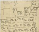
| Date: | 1922 |
|---|---|
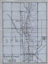
| Description: | A hand-sketched map representing 1850 data of southern and eastern Wisconsin displaying the demographical breakouts for the counties in those areas, showin... |
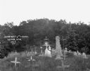
| Date: | 1922 |
|---|---|
| Description: | Tombstones at the cemetery, Looking up towards the chapel. |
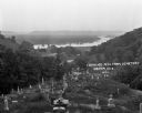
| Date: | 1922 |
|---|---|
| Description: | View from the hilltop at the Genoa cemetery looking down towards the village, the Mississippi River and the Minnesota border. |

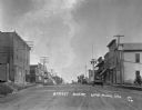
| Date: | 1922 |
|---|---|
| Description: | View down Main Street. The Hotel Waters is on the left and the Highland Hotel is on the right side of the street. |
| Date: | 1922 |
|---|---|
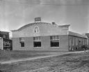
| Description: | An automotive garage with a Ford logo sign affixed to the roof. |

| Date: | 1922 |
|---|---|
| Description: | Children on the porch of a general store and filling station. The business advertises Polarine motor oil, Goodrich tires, Camel cigarettes, and Red Crown g... |

| Date: | 1922 |
|---|---|
| Description: | View down center of railroad tracks with the Lyndon depot on the right. Carriages and carts are along both sides of the tracks. |

| Date: | 1922 |
|---|---|
| Description: | View across street of Saint Mary's Church and School. |
| Date: | 1922 |
|---|---|
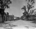
| Description: | View down a commercial street lined with shops and parked cars. On the left is a storefront with signs for "Garage" and "Red Crown Gasoline" above the door... |
| Date: | 1922 |
|---|---|
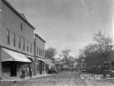
| Description: | View down the curved unpaved street. Two men and a dog stand under the awning of a shop on the left. Another group of men are posed near a car parked outsi... |

| Date: | 1922 |
|---|---|
| Description: | A map of Iron County, Wisconsin, shows sections and the towns of Upson, Hurley, Hamilton, Saxon, and Mercer, lakes and streams, villages, railroads, roads ... |

| Date: | 1922 |
|---|---|
| Description: | A road map of Milwaukee County, Wisconsin that shows the township and range system, towns, communities, completed roads, a proposed system of roads, steam ... |

| Date: | 1922 |
|---|---|
| Description: | A bird's-eye map that shows the Milwaukee Parkway as contemplated by the Milwaukee County Planning Commission. The map identifies the roads and parks throu... |
| Date: | 1922 |
|---|---|
| Description: | A map of the Beaver Creek Valley in Monroe, Wisconsin along Beaver Creek and the La Crosse River, showing roads, railroads, and land ownership as well as p... |
If you didn't find the material you searched for, our Library Reference Staff can help.
Call our reference desk at 608-264-6535 or email us at: