 Filter: Categories of Wisconsin Historical Images
Filter: FULL_DATE of 1927
Filter: Subject of human settlements
Filter: Categories of Wisconsin Historical Images
Filter: FULL_DATE of 1927
Filter: Subject of human settlements
| Date: | 1927 |
|---|---|
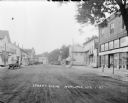
| Description: | Street scene down middle of street, with businesses on both sides. A hotel, the post office, and a hardware store are on the left. A mercantile, ice cream ... |

| Date: | 1927 |
|---|---|
| Description: | Shows campus buildings, points of interest in surrounding area, and railroads. Advertisements on verso. |
| Date: | 1927 |
|---|---|
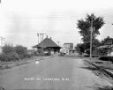
| Description: | A street scene with the train depot on the left. An automobile parked on the street side. A seed store on the next block with someone entering it. There is... |
| Date: | 1927 |
|---|---|
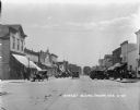
| Description: | A view of downtown Thorp. Lampposts lining the street on both sides. Cars parked at the curbs on both sides. A couple cars driving away down the street. On... |

| Date: | 1927 |
|---|---|
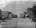
| Description: | View from street of Mathew's Drug Store, which is a two-story brick building with large display windows on the first floor. A number of people are on sidew... |

| Date: | 1927 |
|---|---|
| Description: | View of intersection towards a restaurant and grocery on the left, with dwellings and other buildings in the background. A group of people standing posing ... |

| Date: | 1927 |
|---|---|
| Description: | View down street towards a brick building with a balcony on the corner. A man stands near gas pumps and a lamppost and a woman is crossing the street. A ca... |
| Date: | 1927 |
|---|---|
| Description: | View uphill towards the central business district. Commercial buildings on the left include a service station and Hotel Thorp. On the right are commercial ... |
| Date: | 1927 |
|---|---|
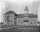
| Description: | A view of the public school, a large two-story brick building with a belfry. Young trees lining the pathway to the entrance. |
| Date: | 1927 |
|---|---|
| Description: | View up drive towards the main building with wrap-around porch. A bicycle is parked at the bottom of the stairs. Guest cottages are behind the main buildin... |
| Date: | 1927 |
|---|---|
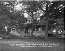
| Description: | Three-quarter view of the main building. A woman us standing on the porch holding a broom, and a bicycle is parked at the bottom of the stairs. Tennis rack... |

| Date: | 1927 |
|---|---|
| Description: | Two small wood-frame cottages behind the main building at Black Oaks. A section of the porch of the main building is on the far right. |

| Date: | 1927 |
|---|---|
| Description: | Algerian Muslims touching their foreheads to the ground in prayer outside of a mosque. |

| Date: | 1927 |
|---|---|
| Description: | View of the main building at the Grandview Hotel. There are women posed on the porch and on the lawn near the front walk. |

| Date: | 1927 |
|---|---|
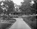
| Description: | Exterior view of a house in a residential neighborhood with a large screened-in porch, and a bench and a lawn swing in the front yard. |

| Date: | 1927 |
|---|---|
| Description: | Two-story cottage with a built-in garage. There is a young vine over the roofed entrance, and a bench and potted plant near the garage door. |

| Date: | 1927 |
|---|---|
| Description: | A collection of views of a guest house at Broadway at Capitol, and sites around the Dells, including: The Narrows of the Dells of the Wisconsin River, Stan... |

| Date: | 1927 |
|---|---|
| Description: | This map includes an index and highways marked in red. Attractions on the map include: Four Mile House, Cold Springs, Grand Crossing Station, Coleman Sloug... |
| Date: | 1927 |
|---|---|
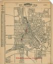
| Description: | This map shows a plat of city, a numbering system, local streets, railroads, and part of the Rock River. The map is indexed by street name and reads: "Copy... |

| Date: | 1927 |
|---|---|
| Description: | This map shows street car lines, bus routes, railroads, proposed city boundary lines, wards, public schools, blocks & house numbers, Lake Michigan, one mil... |
If you didn't find the material you searched for, our Library Reference Staff can help.
Call our reference desk at 608-264-6535 or email us at: