 Filter: Categories of Wisconsin Historical Images
Filter: FULL_DATE of 1928
Filter: Categories of Wisconsin Historical Images
Filter: FULL_DATE of 1928

| Date: | 1928 |
|---|---|
| Description: | Interior elevated view of St. Francis Xavier Church looking towards the altar. Note the American and religious flags and bunting decorating the pillars and... |
| Date: | 1928 |
|---|---|
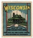
| Description: | Stamp for Wisconsin created during or after President Calvin Coolidge's 1928 summer visit to Wisconsin. President Coolidge spent the summer fishing on the ... |
| Date: | 1928 |
|---|---|
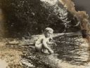
| Description: | William O. Petersen, youngest son of William F. and Alma Schmidt Petersen, plays at the Geneva Lake shore. There is a picnic basket in the background and a... |

| Date: | 1928 |
|---|---|
| Description: | Waist-up, seated portrait of Alma Schmidt Petersen holding her son, William O. Petersen. She is wearing a dark dress with a lace collar, and a beaded neckl... |
| Date: | 1928 |
|---|---|
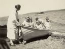
| Description: | Alma Schmidt Petersen, standing on the shore of Geneva Lake at Black Point, steadies a rowboat with her three sons and two other boys in it. Conrad Peterse... |
| Date: | 1928 |
|---|---|
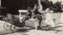
| Description: | Conrad, resting his feet in a baby carriage, and Edward, center, sit on a bench on the pier at Black Point; their younger brother William stands at right. ... |

| Date: | 1928 |
|---|---|
| Description: | This map shows rates on cattle, hogs and sheep, and mileage from Wisconsin points to Chicago, Illinois. The top margin reads: "Before the Interstate Commer... |

| Date: | 1928 |
|---|---|
| Description: | Exterior view of the Elmer Droster home at 5301 Felland Road. There is a garage on the left, and in the far background a ridge with trees. |

| Date: | 1928 |
|---|---|
| Description: | Elevated view of three men using a horse-drawn combine. Letter accompanying the image reads: ". . . we are mailing you to-day, picture of the first Combine... |

| Date: | 1928 |
|---|---|
| Description: | This map shows the state trunk highway system and county trunk highways. The lower left corner includes a legend of roadway types. Lake Michigan and Lake S... |

| Date: | 1928 |
|---|---|
| Description: | This map shows a view of the Milwaukee metropolitan area. It highlights state trunk highways, principal county trunks and other secondary highways and type... |

| Date: | 1928 |
|---|---|
| Description: | Quarter-length profile portrait of Freddie Mae Hill, the first African-American resident of Madison to graduate from the University of Wisconsin, Madison H... |

| Date: | 1928 |
|---|---|
| Description: | Truck with trailer loaded with lumber. More lumber is stacked under a roofed storage area in the background. Sign on front and side of truck reads: "W.R. B... |

| Date: | 1928 |
|---|---|
| Description: | Left side view of a man sitting on a horse-drawn dump rake. Another man is standing behind him. Farm buildings are across a road in the background. |

| Date: | 1928 |
|---|---|
| Description: | View across field towards a man driving a large team of horses pulling a harvester thresher. A man is standing in the field in the foreground. A silo, a lo... |

| Date: | 1928 |
|---|---|
| Description: | A man is standing in a field near a harvester-thresher pulled by a large team of horses. The horses are wearing fly-nets. Three other men are standing on t... |
| Date: | 1928 |
|---|---|
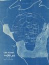
| Description: | This blue line map shows the number of carload shipments to northern and central counties, with Mosinee being the central distribution point. Lake Michigan... |

| Date: | 1928 |
|---|---|
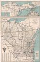
| Description: | This map shows county boundaries, cities, rivers, lakes, roads and points of interest. Included are portions of Minnesota, Iowa, Illinois, and Michigan. La... |

| Date: | 1928 |
|---|---|
| Description: | This map shows roads, cities, lakes, rivers, points of interest and county boundaries. Through routes are outlined in red. Includes an index to cities and ... |
| Date: | 1928 |
|---|---|
| Description: | This map shows U.S., state, county highways, cities, county boundaries, lakes, rivers, and points of interest. At the top of the map it shows the Upper Mic... |
If you didn't find the material you searched for, our Library Reference Staff can help.
Call our reference desk at 608-264-6535 or email us at: