 Filter: Categories of Wisconsin Historical Images
Filter: FULL_DATE of 1929
Filter: Subject of human settlements
Filter: Subject of transportation
Filter: Categories of Wisconsin Historical Images
Filter: FULL_DATE of 1929
Filter: Subject of human settlements
Filter: Subject of transportation

| Date: | 1929 |
|---|---|
| Description: | Map shows townships and sections, landownership and acreages, roads, schools, school districts, churches, and cemeteries. Includes index of acreage tracts. |

| Date: | 1929 |
|---|---|
| Description: | "Compliments of the Douglas County Highway Department"--Top margin. Shows state-trunk highways, county highways, town roads, trails, boundaries, and concr... |
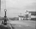
| Date: | 1929 |
|---|---|
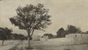
| Description: | View from town of the road leading out of town towards fields and low hills. On the left at the curb is a fire hydrant and a Red Crown Gasoline gas pump. A... |
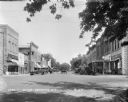
| Date: | 1929 |
|---|---|
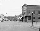
| Description: | View down street at intersection of commercial buildings on both sides. On the left is a drug store/soda fountain, restaurant and a cafe. On the right is a... |

| Date: | 1929 |
|---|---|
| Description: | This map is oriented with north to the upper right. Includes index of retailers and buildings, with some advertisements in margins. |
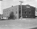
| Date: | 1929 |
|---|---|
| Description: | View from street of City Hall building on a corner. There are garages in the back on the left. On the corner there is a stop sign, a Hwy 51 signpost, and a... |
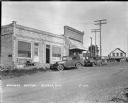
| Date: | 1929 |
|---|---|
| Description: | View across street of a cash store on the left with a handcart near the door and automobiles parked at the curb. A gas pump is on the corner. In the backgr... |
| Date: | 1929 |
|---|---|
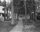
| Description: | A view of small wooden houses on each side of a tree-lined path. Two children with a bicycle are standing on the path in the middle distance, near another ... |

| Date: | 1929 |
|---|---|
| Description: | Elevated view of Viola and neighboring farms in a valley surrounded by rolling hills. |

| Date: | 1929 |
|---|---|
| Description: | View down unpaved street scene towards an intersection. A tree and a fire hydrant on the corner on the left. On the right is a garage with a ramp entrance ... |
| Date: | 1929 |
|---|---|
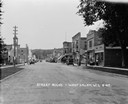
| Description: | View down middle of street towards central business section. On the left is a building with a belfry. Cars and businesses line both sides of the street, pe... |
| Date: | 1929 |
|---|---|
| Description: | View down middle of Main Street paved with cobblestones. There is a railroad crossing at the far end, and the ridge of a hill in the far background. A barb... |
| Date: | 1929 |
|---|---|
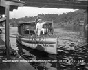
| Description: | View from pier of a Native American man wearing a headdress kneeling on a tourist boat called "Black Hawk" docked under a bridge in the Wisconsin River. He... |

| Date: | 1929 |
|---|---|
| Description: | High suspension bridge over gorge at Constantine in north eastern Algeria. |
| Date: | 1929 |
|---|---|
| Description: | Outside the walls of Tebessa, in north eastern Algeria. Hills are in the far background. |

| Date: | 1929 |
|---|---|
| Description: | View across street towards three women standing on the front steps of Winnes Inn, a converted dwelling in a residential neighborhood. |

| Date: | 1929 |
|---|---|
| Description: | This is a blue line print map that shows local streets, railroads, local businesses, schools, parks, cemeteries, the airport, the state capitol, the Univer... |

| Date: | 1929 |
|---|---|
| Description: | View from street towards the Denmark State Bank, which is heavily covered with ivy. There is a flagpole at the corner flying the American flag. Caption rea... |
| Date: | 1929 |
|---|---|
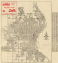
| Description: | This map shows streets, railroads, parks, cemeteries, and a proposed harbor. The top margin includes an advertisement for Delco Motor Oil and the right mar... |
| Date: | 1929 |
|---|---|
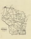
| Description: | This map shows railroad routes throughout the state. |
If you didn't find the material you searched for, our Library Reference Staff can help.
Call our reference desk at 608-264-6535 or email us at: