Filter: Categories of Wisconsin Historical Images
Filter: FULL_DATE of 1929
Filter: Subject of human settlements
Filter: Categories of Wisconsin Historical Images
Filter: FULL_DATE of 1929
Filter: Subject of human settlements

| Date: | 1929 |
|---|---|
| Description: | View down a street lined with shops and cars. The storefronts include Frank's Place and the Cozy Corner Cafe. |
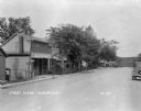
| Date: | 1929 |
|---|---|
| Description: | View down unpaved street of a row of storefronts. |

| Date: | 1929 |
|---|---|
| Description: | Exterior of Droster's Grocery and Filling Station on Highway 13. The business features three gas pumps. |

| Date: | 1929 |
|---|---|
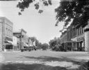
| Description: | View down High Street looking east. There are many automobiles parked along the curb, and shops line the street. At the end of the street down the hill is ... |

| Date: | 1929 |
|---|---|
| Description: | View across street of the three-story grade school. |

| Date: | 1929 |
|---|---|
| Description: | The Marshall Memorial Hall building, located at 30 Wisconsin Dells Parkway South. The building currently serves as the Village Hall of Lake Delton. |
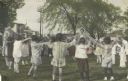
| Date: | 1929 |
|---|---|
| Description: | Hand-colored image from a scrapbook kept by Neighborhood House, with a group of children and two women playing a circle game outdoors. |

| Date: | 1929 |
|---|---|
| Description: | This 1929 topographic map of Trempealeau County, Wisconsin, shows the topography, lakes, streams and wetlands, township and range grid, sections, cities an... |

| Date: | 1929 |
|---|---|
| Description: | Map shows townships and sections, landownership and acreages, roads, schools, school districts, churches, and cemeteries. Includes index of acreage tracts. |

| Date: | 1929 |
|---|---|
| Description: | "Compliments of the Douglas County Highway Department"--Top margin. Shows state-trunk highways, county highways, town roads, trails, boundaries, and concr... |
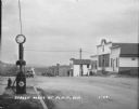
| Date: | 1929 |
|---|---|
| Description: | View from town of the road leading out of town towards fields and low hills. On the left at the curb is a fire hydrant and a Red Crown Gasoline gas pump. A... |
| Date: | 1929 |
|---|---|
| Description: | View down street at intersection of commercial buildings on both sides. On the left is a drug store/soda fountain, restaurant and a cafe. On the right is a... |

| Date: | 1929 |
|---|---|
| Description: | This map is oriented with north to the upper right. Includes index of retailers and buildings, with some advertisements in margins. |
| Date: | 1929 |
|---|---|
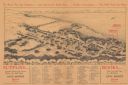
| Description: | Bird’s-eye view map. Top of map reads: "To Show You the Campus ... and Gatewood's Book Store ... Further Instructions ... You Will Need No More". Bottom le... |
| Date: | 1929 |
|---|---|
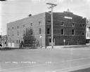
| Description: | View from street of City Hall building on a corner. There are garages in the back on the left. On the corner there is a stop sign, a Hwy 51 signpost, and a... |
| Date: | 1929 |
|---|---|
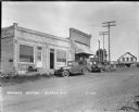
| Description: | View across street of a cash store on the left with a handcart near the door and automobiles parked at the curb. A gas pump is on the corner. In the backgr... |

| Date: | 1929 |
|---|---|
| Description: | View of front of the public school, a two-story brick building with a cupola and flagpole over the bell. A cornfield and bluff are in the background. |
| Date: | 1929 |
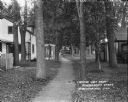
|---|---|
| Description: | A view of small wooden houses on each side of a tree-lined path. Two children with a bicycle are standing on the path in the middle distance, near another ... |

| Date: | 1929 |
|---|---|
| Description: | Elevated view of Viola and neighboring farms in a valley surrounded by rolling hills. |
If you didn't find the material you searched for, our Library Reference Staff can help.
Call our reference desk at 608-264-6535 or email us at: