 Filter: Categories of Wisconsin Historical Images
Filter: FULL_DATE of 1930
Filter: Subject of aerial photographs
Filter: Categories of Wisconsin Historical Images
Filter: FULL_DATE of 1930
Filter: Subject of aerial photographs

| Date: | 1930 |
|---|---|
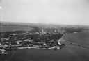
| Description: | Aerial view of the city and the river. |

| Date: | 1930 |
|---|---|
| Description: | Aerial view of Carson Park, Half Moon Lake and part of the West Side in the foreground. The municipal bath house is on the lake shore in the foreground. A ... |

| Date: | 1930 |
|---|---|
| Description: | Aerial view of city, with Eau Claire River is in the foreground with Milwaukee railroad bridge at left. Gillette Rubber Co. plant is in center with Omaha r... |

| Date: | 1930 |
|---|---|
| Description: | Aerial view above Shorewood Hills near Madison, looking northeast. |

| Date: | 1930 |
|---|---|
| Description: | Aerial view of isthmus looking east toward Lake Mendota and the Wisconsin State Capitol, with Lake Monona and the horizon in the background. |
| Date: | 1930 |
|---|---|
| Description: | Aerial view of Turville Point and Turville farm, Lake Monona. |
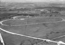
| Date: | 1930 |
|---|---|
| Description: | Aerial view of the Dane County fairgrounds, including several buildings and a track. |
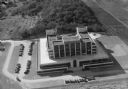
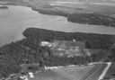
| Date: | 1930 |
|---|---|
| Description: | Aerial view of the Forest Products Laboratory, 1 Gifford Pinchot Drive. |
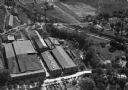
| Date: | 1930 |
|---|---|
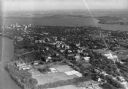
| Description: | Aerial view of the Highway Trailer plant at Edgerton. |
| Date: | 1930 |
|---|---|
| Description: | Aerial view of a portion of the University of Wisconsin-Madison campus and the shoreline of Lake Mendota. |
| Date: | 1930 |
|---|---|
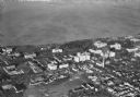
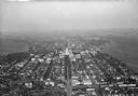
| Description: | Aerial view of the town, including business, houses, and railroad tracks cutting through the town. |
| Date: | 1930 |
|---|---|
| Description: | Aerial view looking southeast, towards the city, including the Wisconsin State Capitol, the central business district, the Capitol Square, both Lake Mendot... |
| Date: | 1930 |
|---|---|
| Description: | Aerial view of the University of Wisconsin-Madison, lakeshore dormitories, Adams Hall and Tripp Hall, also known as Van Hise Dormitories. Buildings include... |
| Date: | 1930 |
|---|---|
| Description: | Aerial view of the Isthmus and the city of Madison including the downtown business district, the Wisconsin State Capitol, both Lake Mendota and Lake Monona... |

| Date: | 1930 |
|---|---|
| Description: | Aerial view of the University of Wisconsin-Madison campus, the State Historical Society of Wisconsin building, Lake Mendota, residential areas and the surr... |
| Date: | 1930 |
|---|---|
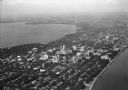
| Description: | Aerial view of the city and the Isthmus, the Wisconsin State Capitol, the downtown business district, and both Lake Mendota and Lake Monona. |
| Date: | 1930 |
|---|---|
| Description: | Aerial view of the city, including the Isthmus, the Wisconsin State Capitol, the downtown business district, Lake Mendota, and Lake Monona. |
| Date: | 1930 |
|---|---|
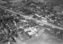
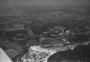
| Description: | Aerial view of the town of Wisconsin Dells, the dam on the Wisconsin River, and the generating plant. The town of Wisconsin Dells was known as Kilbourn Cit... |

| Date: | 1930 |
|---|---|
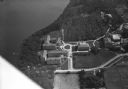
| Description: | Aerial view of the Wisconsin State Capitol, the surrounding businesses, and Lake Monona. |
If you didn't find the material you searched for, our Library Reference Staff can help.
Call our reference desk at 608-264-6535 or email us at:
