 Filter: Categories of Wisconsin Historical Images
Filter: FULL_DATE of 1930
Filter: Subject of automobile driving
Filter: Categories of Wisconsin Historical Images
Filter: FULL_DATE of 1930
Filter: Subject of automobile driving
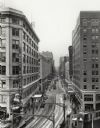
| Date: | 1930 |
|---|---|
| Description: | Elevated view down Wisconsin Avenue looking west, with the RKO Riverside Theatre on the right, and a large Christmas sign on the corner of a building on th... |
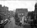
| Date: | 1930 |
|---|---|
| Description: | Elevated view of the junction of Congress and First Streets downtown, featuring cars, pedestrians, storefronts, and railroad tracks. |

| Date: | 1930 |
|---|---|
| Description: | Pictorial map of Glacier National Park, Montana and Waterton Lakes National Park, Alberta. Illustrated by Joe Scheurle, it depicts white people, American ... |
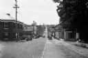
| Date: | 1930 |
|---|---|
| Description: | View down middle of road of car driving across a bridge over Sugar River. Another car is parked by the Wisconsin Power and Light Company. |
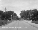
| Date: | 1930 |
|---|---|
| Description: | View down Midland Trail. Automobiles are parked on either side of the street outside an Amoco Station and other stores and dwellings. |
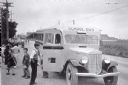
| Date: | 1930 |
|---|---|
| Description: | View down side of road of a group of children exiting an International school bus. On the front and side of the bus is painted the "International" emblem. ... |

| Date: | 1930 |
|---|---|
| Description: | This map shows the entire state plus portions of Illinois, Iowa, Minnesota, and Michigan outlined in blue. The map shows roads, state parks (black triangle... |
If you didn't find the material you searched for, our Library Reference Staff can help.
Call our reference desk at 608-264-6535 or email us at: