Filter: Categories of Wisconsin Historical Images
Filter: FULL_DATE of 1930
Filter: Subject of michigan, lake
Filter: Categories of Wisconsin Historical Images
Filter: FULL_DATE of 1930
Filter: Subject of michigan, lake

| Date: | 1930 |
|---|---|
| Description: | Page 8 of the 1930 schedule is a map of the routes of the Goodrich Steamship Lines in Lake Michigan and Lake Huron. |
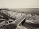
| Date: | 1930 |
|---|---|
| Description: | Elevated view of Lincoln Memorial Drive at the point where it joins Wisconsin Avenue, now the site of the Milwaukee County War Memorial Center. Lake Michig... |

| Date: | 1930 |
|---|---|
| Description: | Alice Holloway standing in front of a flowering rose bush along the shore of Lake Michigan during a trip to Milwaukee to celebrate her engagement. |

| Date: | 1930 |
|---|---|
| Description: | Color illustration of the Rush Street Bridge and Chicago River as it appeared in 1861. Includes the C.H. McCormick Reaper Works on the far side of the rive... |

| Date: | 1930 |
|---|---|
| Description: | Pen and ink map on paper of Wisconsin and northern Illinois showing stagecoach routes (marked in red) that traveled between Lake Michigan and the Mississip... |

| Date: | 1930 |
|---|---|
| Description: | This map shows Indian trails through Wisconsin counties. The trail are in red ink. Lake Michigan, Green Bay, Lake Superior, and the Wisconsin River are lab... |

| Date: | 1930 |
|---|---|
| Description: | Aerial view, looking northeast, across Mud Lake with North Bay in the background, showing cultivated fields and wooded land. |

| Date: | 1930 |
|---|---|
| Description: | Aerial view looking north across the wooded peninsula separating Europe Bay (top) from Newport Bay. This area is now part of Newport State Park. |

| Date: | 1930 |
|---|---|
| Description: | Aerial view of the northern tip of the Door Peninsula, looking north. Europe Lake is in the center, with Europe Bay to the right. Plum Island and Washingto... |

| Date: | 1930 |
|---|---|
| Description: | Aerial view looking northeast, with Rowley's Bay in the foreground. Europe Lake is to the left, with Europe Bay and Newport Bay separated by a narrow peni... |

| Date: | 1930 |
|---|---|
| Description: | Aerial view over northern Door County, looking northeast across Europe Lake and Europe Bay toward Plum and Washington Islands. Farm fields and orchards con... |

| Date: | 1930 |
|---|---|
| Description: | Aerial view from over Moonlight Bay, looking east across Bues Point to Spike Horn Bay and Cana Island. The Cana Island Lighthouse is seen as a ship passes ... |

| Date: | 1930 |
|---|---|
| Description: | Aerial view, looking north, across the beach and pier on Europe Bay to Europe Lake and beyond to Washington Island. The land south (to the right) of Europe... |

| Date: | 1930 |
|---|---|
| Description: | This map shows streets, railways, bus lines, railroads, roads, parks, cemeteries, Lake Michigan, and a proposed harbor. Also included is a legend and on th... |

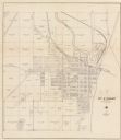
| Date: | 1930 |
|---|---|
| Description: | This map shows the state trunk highway system and county trunk highways. This map show surface type on state and county trunk highways and the locations of... |
| Date: | 1930 |
|---|---|
| Description: | This cadastral map shows ownership and acreage of lots. Streets, the Kewaunee River, and Lake Michigan are labeled. |

| Date: | 1930 |
|---|---|
| Description: | This map shows rivers, lakes, trails, Indian villages, distances, and boundaries of tracts ceded by the Munnomonee, Winnebaygoes, and New York Indians Trib... |

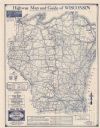
| Date: | 1930 |
|---|---|
| Description: | This map shows surface types on the highways including: concrete, bit, mat, gravels, shales, and unsurfaced. County boundaries, cities, rivers, roads, high... |
| Date: | 1930 |
|---|---|
| Description: | This map shows types of roadways, cities, lakes, rivers, county boundaries and points of interest. Included are portions of Minnesota, Iowa, Illinois, and ... |
If you didn't find the material you searched for, our Library Reference Staff can help.
Call our reference desk at 608-264-6535 or email us at: