 Filter: Categories of Wisconsin Historical Images
Filter: FULL_DATE of 1930
Filter: Subject of state parks and reserves
Filter: Categories of Wisconsin Historical Images
Filter: FULL_DATE of 1930
Filter: Subject of state parks and reserves

| Date: | 1930 |
|---|---|
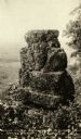
| Description: | A rock formation in Wyalusing State Park known as the "Black Hawk Monument." The park's original name, Nelson Dewey, was later given to a different state p... |
| Date: | 1930 |
|---|---|
| Description: | A rock formation known as "Black Hawk Monument" in Wyalusing State Park. The park's original name, Nelson Dewey, was later given to a different state park ... |
| Date: | 1930 |
|---|---|
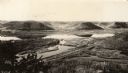
| Description: | Elevated view of Perrot State Park (Trempealeau vicinity) looking west from Brady's Bluff toward the Mississippi River and Minnesota. Railroad tracks run a... |

| Date: | 1930 |
|---|---|
| Description: | Aerial view looking east at Mt. Trempealeau from Brady's Bluff in Perrot State Park. The Mississippi River is visible along the bluffs at upper left, and t... |
| Date: | 1930 |
|---|---|
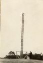
| Description: | A totem pole erected in 1927 in honor of the aboriginal inhabitants of Wisconsin. Potawatomi chief Simon Onanguisse Kahquados (1851-November 27, 1930), an ... |
| Date: | 1930 |
|---|---|
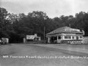
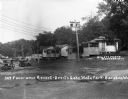
| Description: | View of the entrance to Devil's Lake State Park. There is an information center offering gas, food, and Blatz beer. Two storekeepers and a boy sit on the p... |
| Date: | 1930 |
|---|---|
| Description: | View of a row of cabins at the Panoramic Resort. There are two cars parked on the left. |
| Date: | 1930 |
|---|---|
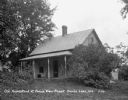
| Description: | Cottage, with a spinning wheel on the porch, at the Bonnie View Resort near Devil's Lake. |

| Date: | 1930 |
|---|---|
| Description: | Aerial view looking north across the wooded peninsula separating Europe Bay (top) from Newport Bay. This area is now part of Newport State Park. |

| Date: | 1930 |
|---|---|
| Description: | Aerial view of the northern tip of the Door Peninsula, looking north. Europe Lake is in the center, with Europe Bay to the right. Plum Island and Washingto... |

| Date: | 1930 |
|---|---|
| Description: | Aerial view looking northeast, with Rowley's Bay in the foreground. Europe Lake is to the left, with Europe Bay and Newport Bay separated by a narrow peni... |

| Date: | 1930 |
|---|---|
| Description: | Aerial view over northern Door County, looking northeast across Europe Lake and Europe Bay toward Plum and Washington Islands. Farm fields and orchards con... |

| Date: | 1930 |
|---|---|
| Description: | Aerial view, looking north, across the beach and pier on Europe Bay to Europe Lake and beyond to Washington Island. The land south (to the right) of Europe... |

| Date: | 1930 |
|---|---|
| Description: | This map shows the entire state plus portions of Illinois, Iowa, Minnesota, and Michigan outlined in blue. The map shows roads, state parks (black triangle... |
| Date: | 1930 |
|---|---|
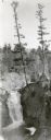
| Description: | An elevated view of Brownstone Falls. Two tall pines are growing at the top edge of a rock to the right of the falls. |

| Date: | 1930 |
|---|---|
| Description: | An elevated view of the rock formation in Devil's Lake State Park known as Cleopatra's Needle. |

| Date: | 1930 |
|---|---|
| Description: | Elevated view of wooded bluffs lining the shoreline of a narrow part of Mirror Lake in this view taken from Ferndale Cliff. |

| Date: | 1930 |
|---|---|
| Description: | Men, women and children in modest swimming suits enjoy splashing and playing in the water at Sandy Beach, a resort established by Gerhard Strauss in 1921. ... |
If you didn't find the material you searched for, our Library Reference Staff can help.
Call our reference desk at 608-264-6535 or email us at: