 Filter: Categories of Wisconsin Historical Images
Filter: FULL_DATE of 1930
Filter: Subject of superior, lake
Filter: Categories of Wisconsin Historical Images
Filter: FULL_DATE of 1930
Filter: Subject of superior, lake
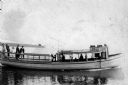
| Date: | 1930 |
|---|---|
| Description: | Group of people on board the steamboat "Byng I" sometime prior to 1930. |
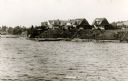
| Date: | 1930 |
|---|---|
| Description: | View from water of cottages along the shoreline in Nebraska Row, La Pointe, Madeline Island. Caption reads: "Nebraska Row — La Pointe, Wis." |

| Date: | 1930 |
|---|---|
| Description: | Caption reads: "'The Old Standby' First Lighthouse Built at the Head of Lake Superior—Superior Entry — 1854 Keepers, Com. Saxton and Samuel Palmer." |

| Date: | 1930 |
|---|---|
| Description: | Large group of fishermen standing on ice with catch of fish displayed on airplane wing near La Pointe, Madeline Island. |

| Date: | 1930 |
|---|---|
| Description: | This map shows Indian trails through Wisconsin counties. The trail are in red ink. Lake Michigan, Green Bay, Lake Superior, and the Wisconsin River are lab... |
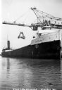
| Date: | 1930 |
|---|---|
| Description: | View of the ship "Alex B. Uhrig" in the process of coal unloading on the Reiss Coal Dock No. 2. |

| Date: | 1930 |
|---|---|
| Description: | Shows county system of roads which are surfaced, well graded, common, or unimproved, town roads, state trunk highways, town and village boundaries, schools... |

| Date: | 1930 |
|---|---|
| Description: | Shows county system of roads which are surfaced, well graded, common, or unimproved, town roads, state trunk highways, town and village boundaries, schools... |

| Date: | 1930 |
|---|---|
| Description: | This map shows the state trunk highway system and county trunk highways. This map show surface type on state and county trunk highways and the locations of... |

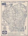
| Date: | 1930 |
|---|---|
| Description: | This map shows surface types on the highways including: concrete, bit, mat, gravels, shales, and unsurfaced. County boundaries, cities, rivers, roads, high... |
| Date: | 1930 |
|---|---|
| Description: | This map shows types of roadways, cities, lakes, rivers, county boundaries and points of interest. Included are portions of Minnesota, Iowa, Illinois, and ... |

| Date: | 1930 |
|---|---|
| Description: | This map shows county boundaries, roads, cities, highways, points of interest, and the locations of Standard Oil Company Service Stations. Included are por... |

| Date: | 1930 |
|---|---|
| Description: | This map shows the entire state plus portions of Illinois, Iowa, Minnesota, and Michigan outlined in blue. The map shows roads, state parks (black triangle... |
If you didn't find the material you searched for, our Library Reference Staff can help.
Call our reference desk at 608-264-6535 or email us at: