 Filter: Categories of Wisconsin Historical Images
Filter: FULL_DATE of 1932
Filter: Subject of wisconsin river (wis.)
Filter: Categories of Wisconsin Historical Images
Filter: FULL_DATE of 1932
Filter: Subject of wisconsin river (wis.)
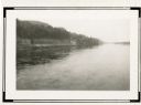
| Date: | 1932 |
|---|---|
| Description: | A view, looking west, from the bridge over the Wisconsin River at Lone Rock. A ledge has been cut into the bluff on the left to accommodate County Highway ... |

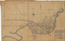
| Date: | 1932 |
|---|---|
| Description: | This map of Wausau shows lots and landownership, buildings, roads, railroads, parks, city wards, and the Wisconsin River. The map features an inset map sho... |
| Date: | 1932 |
|---|---|
| Description: | This blue line print plat map shows local streets, numbered blocks and lots, village limits, and land ownership by name. Also included are manuscript annot... |
If you didn't find the material you searched for, our Library Reference Staff can help.
Call our reference desk at 608-264-6535 or email us at: