 Filter: Categories of Wisconsin Historical Images
Filter: FULL_DATE of 1933
Filter: Subject of lakes
Filter: Categories of Wisconsin Historical Images
Filter: FULL_DATE of 1933
Filter: Subject of lakes
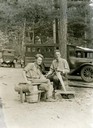
| Date: | 1933 |
|---|---|
| Description: | Baum and Hasler building lime floats at Trout Lake. |
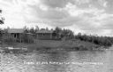
| Date: | 1933 |
|---|---|
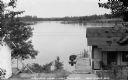
| Description: | Modest cabins located along shoreline of Turtle Flowage on a cloudy day. |
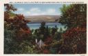
| Date: | 1933 |
|---|---|
| Description: | Colorized postcard of Devil's Lake and bluffs seen through the trees. Some of the trees have autumn color. A roof and chimney are visible. The text at the ... |
| Date: | 1933 |
|---|---|
| Description: | Colorized postcard of the rock formation called the Devil's Doorway in Devil's Lake State Park. Trees can be seen to the right and below. The lake, bluffs ... |
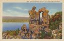
| Date: | 1933 |
|---|---|
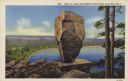
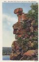
| Description: | Colorized postcard of Balance Rock, a formation in Devil's Lake State Park. There are carved initials and other markings on the rock formation. A tree is v... |
| Date: | 1933 |
|---|---|
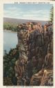
| Description: | Colorized postcard of the rock formation called Prospect Point in Devil's Lake State Park. Trees and foliage can be seen all around. The lake, shoreline, b... |
| Date: | 1933 |
|---|---|
| Description: | Colorized postcard of the rock formation called the Turk's Head in Devil's Lake State Park. Trees and foliage can be seen to the right and below. The lake,... |
| Date: | 1933 |
|---|---|
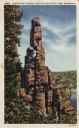
| Description: | Colorized postcard of the rock formation called Cleopatra's Needle in Devil's Lake State Park. Trees can be seen to the left and below. The lake, bluffs an... |
| Date: | 1933 |
|---|---|
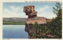
| Description: | Colorized postcard of the rock formation called the Stone Face in Devil's Lake State Park. Trees and shrubs can be seen all around. The lake, bluffs and sk... |

| Date: | 1933 |
|---|---|
| Description: | Colorized postcard of Devil's Lake by moonlight. Two rock formations and trees are in the foreground. The lake, trees, bluffs and sky are in the background... |
| Date: | 1933 |
|---|---|
| Description: | View looking out over Lake Millicent from steep hill at Norseman Lodge. In the foreground is a chair and diving board on the dock. One boat is tied to the ... |
| Date: | 1933 |
|---|---|
| Description: | View looking across the Lake of the Falls at three one-story log cabins with porches, called the Russell Bros Cabins. There are boats along the shoreline. |

| Date: | 1933 |
|---|---|
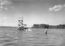
| Description: | View across water of three people sitting in a wooden rowboat on Lake Gogebic near Marenisco. In the background is the shoreline, as well as a large buildi... |

| Date: | 1933 |
|---|---|
| Description: | This map shows the physical geography and basic geological features of Wisconsin and includes a geological cross-section from Lake Pepin to Lake Michigan a... |

| Date: | 1933 |
|---|---|
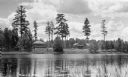
| Description: | Two women stand on the lawn looking at Lake Owen. There are wooden benches, trees, and a rowboat on the right. The White Pine Lodge with porches is on the ... |
| Date: | 1933 |
|---|---|
| Description: | View across water of a shoreline with stone steps and wall leading up to a cabin among trees. There is a dog on the left near the steps, and a wooden canoe... |

| Date: | 1933 |
|---|---|
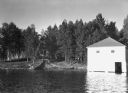
| Description: | View across water of a one-story wood cabin on the shoreline of a lake. There are plants and trees on shore. In the foreground are lily pads, and the image... |
| Date: | 1933 |
|---|---|
| Description: | View of men, women, and children wearing swimsuits playing on and swimming near a wooden swimming and diving platform in a lake. In the distance is the far... |

| Date: | 1933 |
|---|---|
| Description: | This road map shows state and county roads in Wisconsin, northern Illinois, northeastern Iowa, eastern Minnesota, and the western portion of Michigan's Upp... |

| Date: | 1933 |
|---|---|
| Description: | This map of Wisconsin and eastern Minnesota identifies federal and state highways in the area. Railroads are shown with the mileage between stops indicated... |
If you didn't find the material you searched for, our Library Reference Staff can help.
Call our reference desk at 608-264-6535 or email us at: