Filter: Categories of Wisconsin Historical Images
Filter: FULL_DATE of 1934
Filter: Subject of formations (geology)
Filter: Categories of Wisconsin Historical Images
Filter: FULL_DATE of 1934
Filter: Subject of formations (geology)
| Date: | 1934 |
|---|---|
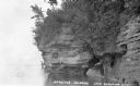
| Description: | View across water of sandstone cliff shoreline along Lake Superior at the Apostle Islands. On the far right a boat is pulled up onshore, and painted on the... |
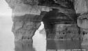
| Date: | 1934 |
|---|---|
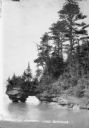
| Description: | View across water of trees and plants covering a sandstone cliff and arch on the shoreline along Lake Superior. Another sandstone arch is in the far backgr... |
| Date: | 1934 |
|---|---|
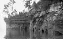
| Description: | View from water of sandstone cliffs and caves on Lake Superior shoreline. |
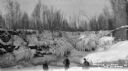
| Date: | 1934 |
|---|---|
| Description: | Three men standing on frozen Lake Superior in front of ice covered shoreline. |
| Date: | 1934 |
|---|---|
| Description: | View from water of sandstone shoreline on south shore of Lake Superior. |
| Date: | 1934 |
|---|---|
| Description: | View from water of Devil's Island lighthouse located above sandstone caves and arches in the Apostle Islands of Lake Superior. Caption reads: "Devil's Isla... |

| Date: | 1934 |
|---|---|
| Description: | This 1934 map of Racine County, Wisconsin, shows the township and range grid, cities and villages, vegetation type, land use, roads, railroads, utilities, ... |

| Date: | 1934 |
|---|---|
| Description: | Photographic postcard view along the rocky shoreline of Lake Michigan towards a long pier that jutts out behind the rocky point. Caption reads: "Along the ... |
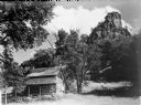
| Date: | 1934 |
|---|---|
| Description: | View looking up towards a log cabin near the base of a tall rock outcropping. |
If you didn't find the material you searched for, our Library Reference Staff can help.
Call our reference desk at 608-264-6535 or email us at: