 Filter: Categories of Wisconsin Historical Images
Filter: FULL_DATE of 1934
Filter: Subject of streams
Filter: Categories of Wisconsin Historical Images
Filter: FULL_DATE of 1934
Filter: Subject of streams
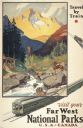
| Date: | 1934 |
|---|---|
| Description: | An original lithograph promoting the national parks of the western United States and Canada, as well as promoting train travel. The poster depicts a creek... |

| Date: | 1934 |
|---|---|
| Description: | This 1930s highway map of Sheboygan County, Wisconsin, shows roads, the township and range grid, towns, sections, cities and villages, and streams, lakes, ... |

| Date: | 1934 |
|---|---|
| Description: | This map of Waukesha County, Wisconsin, from the Wisconsin Land Inventory shows the township and range grid, sections, cities and villages, vegetation type... |

| Date: | 1934 |
|---|---|
| Description: | This 1934 zoning map of Iron County, Wisconsin, shows the township and range grid, towns, sections, roads, and lakes and streams. Forestry and recreation d... |
If you didn't find the material you searched for, our Library Reference Staff can help.
Call our reference desk at 608-264-6535 or email us at: