 Filter: Categories of Wisconsin Historical Images
Filter: FULL_DATE of 1936
Filter: Subject of express highways
Filter: Categories of Wisconsin Historical Images
Filter: FULL_DATE of 1936
Filter: Subject of express highways
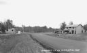
| Date: | 1936 |
|---|---|
| Description: | View looking down Highway 77 at Clam Lake. On the left is a one-story building, Day's Service Station. On the right are two buildings, the one-story Standa... |

| Date: | 1936 |
|---|---|
| Description: | This 1936 Wisconsin Conservation Dept. map shows the locations of state forestry Civilian Conservation Corps (CCC) camps, closed state forestry CCC camps, ... |

| Date: | 1936 |
|---|---|
| Description: | Color coded map in pink, yellow, blue, and brown of Milwaukee County State and County trunk highways. The map includes a legend of symbols: "STEAM RAIL ROA... |

| Date: | 1936 |
|---|---|
| Description: | This road map shows the major roads, cities, lakes, and rivers of Wisconsin and parts of the neighboring states and Canada, as well as advertisements for t... |

| Date: | 1936 |
|---|---|
| Description: | This map shows road surfaces, construction, flying fields, seaplane landings, populations of cities and towns, and ferry routes of Wisconsin and some of th... |

| Date: | 1936 |
|---|---|
| Description: | This colored road map shows automobile roads in Wisconsin as well as portions of nearby states. Information on the quality and type of any given road (pave... |
If you didn't find the material you searched for, our Library Reference Staff can help.
Call our reference desk at 608-264-6535 or email us at: