 Filter: Categories of Wisconsin Historical Images
Filter: FULL_DATE of 1936
Filter: Subject of indian reservations
Filter: Categories of Wisconsin Historical Images
Filter: FULL_DATE of 1936
Filter: Subject of indian reservations

| Date: | 1936 |
|---|---|
| Description: | This map is red and black ink on tracing cloth and is oriented with north to the upper left. This hand-drawn map shows a central portion of the military ro... |
| Date: | 1936 |
|---|---|
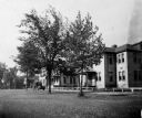
| Description: | St. Joseph's Indian School on the Keshena Menominee Reservation. |

| Date: | 1936 |
|---|---|
| Description: | Loading a large white pine log cut on the Menominee Indian Reservation onto a truck. The log was hauled to the Wisconsin State Fair for a display about the... |

| Date: | 1936 |
|---|---|
| Description: | View across Rainbow Falls on the Wolf River, on the Menominee Indian Reservation. |

| Date: | 1936 |
|---|---|
| Description: | A view of Big Smoky Falls on the Wolf River, on the Menominee Reservation. |
| Date: | 1936 |
|---|---|
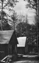
| Description: | Exterior view of a logging camp on the Menominee Indian Reservation. The three buildings are surrounded by forest. |

| Date: | 1936 |
|---|---|
| Description: | This map shows the state trunk highway system and county trunk highways. This map show surface type on state and county trunk highways and the locations of... |
| Date: | 1936 |
|---|---|
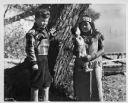
| Description: | Walker Reid (1929-2016) standing alongside tree with Indian girl. Reid Walker shown is 7-years-old, and is the son of Carol McMillan Reid. Portrait taken a... |
If you didn't find the material you searched for, our Library Reference Staff can help.
Call our reference desk at 608-264-6535 or email us at: