 Filter: Categories of Wisconsin Historical Images
Filter: FULL_DATE of 1936
Filter: Subject of michigan, lake
Filter: Categories of Wisconsin Historical Images
Filter: FULL_DATE of 1936
Filter: Subject of michigan, lake
| Date: | 1936 |
|---|---|
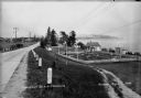
| Description: | Crescent Beach campsite with cabins and miniature golf course by Lake Michigan. |
| Date: | 1936 |
|---|---|
| Description: | Elevated view of Crescent Beach, with campsite with cabins and miniature golf course and other outbuildings. Downtown buildings can be seen in the backgrou... |

| Date: | 1936 |
|---|---|
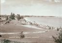
| Description: | Shoreline and wavelets near Red Banks on Lake Michigan. |
| Date: | 1936 |
|---|---|
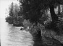
| Description: | Elevated view of the Lake Michigan shoreline and the rocks at Cave Point. |

| Date: | 1936 |
|---|---|
| Description: | An elevated view of Milwaukee Harbor with railroad station looking towards Lake Michigan. |

| Date: | 1936 |
|---|---|
| Description: | This 1936 Wisconsin Conservation Dept. map shows the locations of state forestry Civilian Conservation Corps (CCC) camps, closed state forestry CCC camps, ... |

| Date: | 1936 |
|---|---|
| Description: | This pictorial tourist map from the Wisconsin Conservation Commission depicts vacation activities and identifies tourist destinations throughout the state.... |

| Date: | 1936 |
|---|---|
| Description: | Street map of the City of Milwaukee and surrounding suburbs indicating various mass transit lines. There is an index to Milwaukee streets at the right of t... |

| Date: | 1936 |
|---|---|
| Description: | This map shows the state trunk highway system and county trunk highways. This map show surface type on state and county trunk highways and the locations of... |

| Date: | 1936 |
|---|---|
| Description: | Color coded map in pink, yellow, blue, and brown of Milwaukee County State and County trunk highways. The map includes a legend of symbols: "STEAM RAIL ROA... |

| Date: | 1936 |
|---|---|
| Description: | This map shows campsites, trails, auto roads, surrounding townships, and points of interest, by including pictorial illustrations. Includes an inserted map... |

| Date: | 1936 |
|---|---|
| Description: | This road map shows the major roads, cities, lakes, and rivers of Wisconsin and parts of the neighboring states and Canada, as well as advertisements for t... |

| Date: | 1936 |
|---|---|
| Description: | This map shows road surfaces, construction, flying fields, seaplane landings, populations of cities and towns, and ferry routes of Wisconsin and some of th... |
| Date: | 1936 |
|---|---|
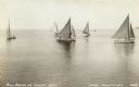
| Description: | Elevated view across water towards small sailboats with two-man crews in Lake Michigan. A tree-lined shoreline is on the far right. |

| Date: | 1936 |
|---|---|
| Description: | This colored road map shows automobile roads in Wisconsin as well as portions of Michigan, Iowa, Minnesota, and Illinois. U.S. numbered highways are shown ... |

| Date: | 1936 |
|---|---|
| Description: | This colored road map shows automobile roads in Wisconsin as well as portions of nearby states. U.S. numbered highways are shown in red, and information ab... |

| Date: | 1936 |
|---|---|
| Description: | This colored road map shows automobile roads in Wisconsin as well as portions of nearby states. Information on the quality and type of any given road (pave... |

| Date: | 1936 |
|---|---|
| Description: | This colored road map shows automobile roads in Wisconsin as well as portions of nearby states. Information on the quality and type of any given road (pave... |
If you didn't find the material you searched for, our Library Reference Staff can help.
Call our reference desk at 608-264-6535 or email us at: