 Filter: Categories of Wisconsin Historical Images
Filter: FULL_DATE of 1936
Filter: Subject of rivers
Filter: Categories of Wisconsin Historical Images
Filter: FULL_DATE of 1936
Filter: Subject of rivers

| Date: | 1936 |
|---|---|
| Description: | This map is red and black ink on tracing cloth and is oriented with north to the upper left. This hand-drawn map shows a central portion of the military ro... |

| Date: | 1936 |
|---|---|
| Description: | View across Rainbow Falls on the Wolf River, on the Menominee Indian Reservation. |

| Date: | 1936 |
|---|---|
| Description: | Two women sitting on top of rocks in the Dells of the Eau Claire River. There is a bridge in the background on the left. |
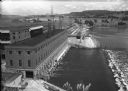
| Date: | 1936 |
|---|---|
| Description: | Elevated view of the power dam on the Wisconsin River at Prairie du Sac. |

| Date: | 1936 |
|---|---|
| Description: | A view of the Dells of the Wisconsin River, with two people walking down a long dock/walkway leading to a boat. |

| Date: | 1936 |
|---|---|
| Description: | A view of Big Smoky Falls on the Wolf River, on the Menominee Reservation. |
| Date: | 1936 |
|---|---|
| Description: | View from shoreline of a bridge over the Ontonagon River. There is snow on the ground with bare the trees in the background. |

| Date: | 1936 |
|---|---|
| Description: | View of two children standing in the Siskiwit River at the top of Bridge Falls. A woman stands on the shore on the right. There are trees and brush on both... |

| Date: | 1936 |
|---|---|
| Description: | This 1936 Wisconsin Conservation Dept. map shows the locations of state forestry Civilian Conservation Corps (CCC) camps, closed state forestry CCC camps, ... |

| Date: | 1936 |
|---|---|
| Description: | This pictorial tourist map from the Wisconsin Conservation Commission depicts vacation activities and identifies tourist destinations throughout the state.... |

| Date: | 1936 |
|---|---|
| Description: | This manuscript map shows the route traveled by the Schoolcraft expedition in July 1831 between the Namekagon River and Lake Owen in the Town of Cable, Bay... |

| Date: | 1936 |
|---|---|
| Description: | This 1936 map of Clark County, Wisconsin, shows the township and range grid, sections, cities and town, and lakes and streams in the county. It lacks the k... |

| Date: | 1936 |
|---|---|
| Description: | This map of Neenah and Menasha shows some parks, churches, convention halls, and other buildings. These points of interest are in red ink. Streets, Little ... |

| Date: | 1936 |
|---|---|
| Description: | Street map of the City of Milwaukee and surrounding suburbs indicating various mass transit lines. There is an index to Milwaukee streets at the right of t... |

| Date: | 1936 |
|---|---|
| Description: | This map shows the state trunk highway system and county trunk highways. This map show surface type on state and county trunk highways and the locations of... |

| Date: | 1936 |
|---|---|
| Description: | Color coded map in pink, yellow, blue, and brown of Milwaukee County State and County trunk highways. The map includes a legend of symbols: "STEAM RAIL ROA... |

| Date: | 1936 |
|---|---|
| Description: | This road map shows the major roads, cities, lakes, and rivers of Wisconsin and parts of the neighboring states and Canada, as well as advertisements for t... |

| Date: | 1936 |
|---|---|
| Description: | This map shows road surfaces, construction, flying fields, seaplane landings, populations of cities and towns, and ferry routes of Wisconsin and some of th... |
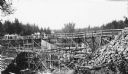
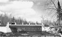
| Date: | 1936 |
|---|---|
| Description: | Two groups of men are standing on a temporary wooden bridge over the Totogatic River. There is a large form in place on the left and a complete concrete wi... |
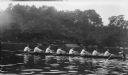
| Date: | 1936 |
|---|---|
| Description: | The photographer's son, Herbert E. Brumder, rowing in the stroke position (second from right) with the Yale freshman crew on the Housatonic River. |
If you didn't find the material you searched for, our Library Reference Staff can help.
Call our reference desk at 608-264-6535 or email us at: